IMAGES TAKEN NEAR TO
Locko Lane, CHESTERFIELD, S45 8AP
Introduction
This page details the photographs taken nearby to Locko Lane, S45 8AP by members of the Geograph project.
The Geograph project started in 2005 with the aim of publishing, organising and preserving representative images for every square kilometre of Great Britain, Ireland and the Isle of Man.

There are currently over 7.5m images from over14,400 individuals and you can help contribute to the project by visiting https://www.geograph.org.uk
Image Map
Images are licensed for reuse under creativecommons.org/licenses/by-sa/2.0
Notes
- Clicking on the map will re-center to the selected point.
- The higher the marker number, the further away the image location is from the centre of the postcode.
Image Listing (60 Images Found)
Images are licensed for reuse under creativecommons.org/licenses/by-sa/2.0
Image
Details
Distance
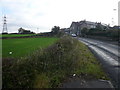
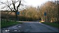
2
Locko Road
The north-easterly photograph shows the point in Image where it turns from running north-westerly to this point (from the right) to running westerly (to the left).
To the right of centre there is a fingerpost pointing to the southern end of a Image (to the right of the post) that connects this point with the Image and Image
To the left of centre the driveway is to Congelton House.
For a more westerly (left) photograph of Locko Road, click here Image
For a more north-easterly (right) photograph showing the road’s junction with Locko Lane, click here Image
Image: © Alan Walker
Taken: 6 Nov 2007
0.05 miles
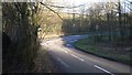
3
Locko Road
The photograph shows the point in Image where it turns from running north-westerly to this point (from behind) to running westerly (ahead and away from this viewpoint).
In the foreground (more obvious on the left) are the walls of a recently rebuilt bridge over a small stream.
Between the two white posts on the right is the southern end of a Image that connects this point with the Image and Image
For a more westerly (ahead and left) photograph of Locko Road, click here Image
For a more north-easterly (behind the viewpoint) photograph showing the road’s junction with Locko Lane, click here Image
Image: © Alan Walker
Taken: 6 Nov 2007
0.05 miles
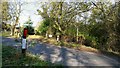
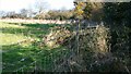
4
Public footpath
This northerly facing photograph of a public footpath is within two or three metres of the paths southern junction with Image in the Waterloo area of Pilsley.
The stile is surrounded by briers and nettles and what traffic passes this point ignores the stile preferring instead to pass to its left.
Immediately ahead of the stile the path is overgrown and shows no sign of being maintained in recent times.
For a more northerly (ahead) photograph of the footpath, click here Image
Image: © Alan Walker
Taken: 6 Nov 2007
0.06 miles
5
Footbridge
This northerly facing photograph shows a footbridge carrying a public footpath over a Locko Brook.
The path behind and ahead is surrounded by briers, nettles and other ground and shows no sign of being maintained in recent times.
For a more north-easterly (ahead) photograph of the footpath, click here Image
For a more southerly (behind the viewpoint) photograph of the footpath, click here Image
Image: © Alan Walker
Taken: 6 Nov 2007
0.07 miles
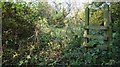
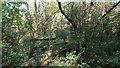
6
Public footpath
This north-easterly facing photograph shows a stile carrying a public footpath from an area of nettles, briers and small trees (behind the viewpoint) into a field (ahead) and thence uphill toward the Image
For a more north-easterly (ahead) photograph of the footpath, click here Image
For a more south-westerly (behind the viewpoint) photograph of the footpath, click here Image
Image: © Alan Walker
Taken: 6 Nov 2007
0.09 miles
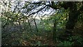
7
Public footpath
This north-easterly facing photograph shows a field where the footpath has been marginalized by the introduction of a barbed wire fence.
The result is a badly maintained, difficult to negotiate footpath, where the walker has not only to negotiate nettles and briers but also the barbs on the wire because they come perilously close at times.
Walkers who are not as sure footed as they once were or families with children would do well to look carefully at this shameful route first before negotiating it.
For a more north-easterly (ahead) photograph of the footpath, click here Image
For a more south-westerly (behind the viewpoint) photograph of the footpath, click here Image
Image: © Alan Walker
Taken: 6 Nov 2007
0.10 miles
9
Locko Lane
The photograph shows the western most end of Locko Lane, looking southwest from its junction with the Five Pits Trail.
From the junction on the left the lane becomes Image
Ahead, Locko Road leads toward Waterloo and Parkhouse Green, whilst the Image (ahead, left) is with Green Lane toward Lower Pilsley.
Behind the viewpoint, Image leads toward Locko Lane Farm and then on to the B6039 at Hardstoft Common.
Off the picture to the right, the Image continues northward toward Timber Lane.
Off the picture to the left, the Image continues southward toward Image in Pilsley.
To see a more easterly (behind the viewpoint) photograph of Locko Lane, click here Image
See also this photograph by Alan Heardman, Image
Image: © Alan Walker
Taken: 14 Feb 2007
0.12 miles
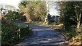
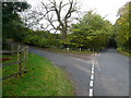
10
Junction
The photograph shows the junction of Green Lane (from behind the viewpoint) with Image (ahead, right) and Locko Road (ahead, left).
For a more south-westerly (behind the viewpoint) photograph of Green Lane, click here Image
Image: © Alan Walker
Taken: 14 Feb 2007
0.13 miles