IMAGES TAKEN NEAR TO
Timber Lane, CHESTERFIELD, S45 8AL
Introduction
This page details the photographs taken nearby to Timber Lane, S45 8AL by members of the Geograph project.
The Geograph project started in 2005 with the aim of publishing, organising and preserving representative images for every square kilometre of Great Britain, Ireland and the Isle of Man.

There are currently over 7.5m images from over14,400 individuals and you can help contribute to the project by visiting https://www.geograph.org.uk
Image Map
Images are licensed for reuse under creativecommons.org/licenses/by-sa/2.0
Notes
- Clicking on the map will re-center to the selected point.
- The higher the marker number, the further away the image location is from the centre of the postcode.
Image Listing (73 Images Found)
Images are licensed for reuse under creativecommons.org/licenses/by-sa/2.0
Image
Details
Distance
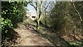
1
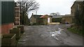
Timber Lane
This south-westerly facing photograph is of Timber Lane¹ and was taken from within a few metres (ahead) of the end of metalled section of the lane.
The building on the left is part of a Image
The garage and building on the right are part of Timber Lane Farm¹.
The building ahead in the distance is part of Broomridding Farm¹.
On the right, running between the house and the hedge, is the start of a farm track. This track carries a Image linking Timber Lane with Williamthorpe Road¹ in the Highfields area of Holmewood.
For another photograph of Timber Lane, taken from a few metres ahead but looking back to face in the opposite direction, click here Image
For a more south-westerly (ahead, by Broomridding Farm) photograph of this public footpath, click here Image
For a more north-easterly (behind the viewpoint) photograph of this public footpath, click here Image
¹ Road/Farm name information from OS Maps at:-
Elgin, http://www.elgin.gov.uk/ or the
Mapping Portal of the Derbyshire Partnership, http://derbyshiremaps.derbyshire.gov.uk/
Image: © Alan Walker
Taken: 27 Nov 2007
0.02 miles
2
Timber Lane
The Five Pits Trail is seen crossing at this point, with Timber Lane Farm through the tunnel of trees.
Image: © Alan Heardman
Taken: 11 Oct 2007
0.02 miles
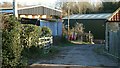
3
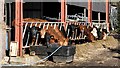
Cattle Barn
A cattle barn at Timber Lane Farm¹, opposite a Image company at the western end of the metalled section of Image¹.
The photograph was taken from a Image linking Timber Lane with Williamthorpe Road¹ in the Highfields area of Holmewood (left, northerly).
This photograph was taken in March. At the end of the November of the same year the barn was being used to store hay.
¹ Road/Farm name information from OS Maps at:-
Elgin, http://www.elgin.gov.uk/ or the
Mapping Portal of the Derbyshire Partnership, http://derbyshiremaps.derbyshire.gov.uk/
Image: © Alan Walker
Taken: 9 Mar 2007
0.02 miles
4
Timber Lane
This north-easterly facing photograph is of Timber Lane¹ and was taken from within a metre or so of the end of metalled section of the lane.
The building on the right is part of a Image
This photograph was taken at the end of November. In the March of the same year the hay barn on the left, part of Timber lane Farm¹, was being used as a Image
On the left, running between the barn and the wall, is the start of a farm track. This track carries a Image linking Timber Lane with Williamthorpe Road¹ in the Highfields area of Holmewood.
Two more photographs taken from nearby viewpoints:
The first of Image was taken from a few metres ahead but is looking back to face the opposite (south-westerly) direction.
The second of Image was taken from a few metres behind this viewpoint and is also facing in the opposite direction.
For a more north-easterly (ahead) photograph of this public footpath, click here Image
For a more south-westerly (behind the viewpoint) photograph of this public footpath, click here Image
¹ Road/Farm name information from OS Maps at:-
Elgin, http://www.elgin.gov.uk/ or the
Mapping Portal of the Derbyshire Partnership, http://derbyshiremaps.derbyshire.gov.uk/
Image: © Alan Walker
Taken: 27 Nov 2007
0.03 miles
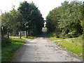
5
Public footpath
This photograph shows a farm track and public footpath linking Image¹ (just ahead, alongside the green building) with Williamthorpe Road¹ in the Highfields area of Holmewood (behind the viewpoint, northerly).
The farm buildings for Timber Lane Farm are built along this track rather than the more traditional/usual farm yard.
Ahead, on the left, is a barn providing storage for hay bales. This photograph was taken in November. In the March of the same year the barn was being used as a Image
The green building ahead is a Image company.
For a photograph taken from the same viewpoint but facing the opposite (south-easterly) direction, click here Image
For a more northerly-westerly (behind the viewpoint) photograph of the footpath, click here Image
¹ Road name information from OS Maps at:-
Elgin, http://www.elgin.gov.uk/ and the
Mapping Portal of the Derbyshire Partnership, http://derbyshiremaps.derbyshire.gov.uk/
Image: © Alan Walker
Taken: 12 Nov 2007
0.03 miles
6
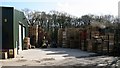
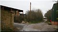
Pallet Repair and Manufacturing
This is a photograph of either the Nottingham Pallet Company or the Chesterfield Pallet Company. This depends upon which web site you find when searching. Either way the ‘two companies’ have the same telephone number and address so perhaps they’re not two companies after all!
The photograph was taken from very near the end of the metalled section of Image¹.
Behind the viewpoint is a Image linking Timber Lane with Williamthorpe Road¹ in the Highfields area of Holmewood.
To the left (some 100metres, easterly) of the viewpoint Timber Lane crosses the Image before continuing toward its junction with the B6039.
To the right (westerly) of the viewpoint the lane continues as a footpath along the side of Broomridding Wood before ending at its junction with a bridleway to Image
Buildings belonging to Timber Lane Farm¹ are behind (northerly) the viewpoint including this Image
¹ Road/Farm name information from OS Maps at:-
Elgin, http://www.elgin.gov.uk/ or the
Mapping Portal of the Derbyshire Partnership, http://derbyshiremaps.derbyshire.gov.uk/
Image: © Alan Walker
Taken: 9 Mar 2007
0.03 miles
7
Timber Lane
The photograph is of Timber Lane¹ (looking in a south-westerly direction) from its crossing with the Image
Ahead (westerly) and on the left (hidden behind the trees but look for the shadow in the road) the lane passes a Image company.
Also ahead, some of whose buildings can be seen, is Timber Lane Farm. It is at this point that the end of the metalled section of the lane is reached. The lane then continues as a footpath along the side of Broomridding Wood before ending at its junction with a bridleway to Image¹.
Behind the viewpoint (easterly) Timber Lane leads to its Image¹.
To see another photograph from almost the same viewpoint but looking approximately 90° anticlockwise (southerly), click here Image
To see another photograph from almost the same viewpoint but looking in the opposite direction (north-easterly), click here Image
For a more south-westerly (ahead) photograph of Timber Lane, click here Image
For a more easterly (behind the viewpoint) photograph of Timber Lane, click here Image
See also this photograph by Alan Heardman, Image
¹ Road name information from OS Maps at:-
Elgin, http://www.elgin.gov.uk/ and the
Mapping Portal of the Derbyshire Partnership, http://derbyshiremaps.derbyshire.gov.uk/
Image: © Alan Walker
Taken: 9 Mar 2007
0.03 miles
8
Timber Lane
This south-westerly facing photograph is of Timber Lane¹ and was taken from within a few metres of the end of the metalled section of the lane.
Timber Lane continues straight forward along the green footpath. The building and track on the right are part of Broomridding Farm¹ and are private.
On the left the yellow sign attached to the route marker post warns of deep water in an area where there is no public access. Keep out!
For another photograph of the lane taken a few metres behind the viewpoint and facing in the opposite direction, click here Image
For a more south-westerly (ahead) photograph of this public footpath, click here Image
For a more north-easterly (behind the viewpoint) photograph of this public footpath, click here Image
¹ Road/Farm name information from OS Maps or the
Mapping Portal of the Derbyshire Partnership, http://derbyshiremaps.derbyshire.gov.uk/
Image: © Alan Walker
Taken: 27 Nov 2007
0.04 miles
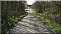
9
Timber Lane
Timber Lane running along the north-western edge of Broomridding Wood.
The buildings ahead are part of Broomridding Farm.
For another photograph of Timber Lane, from a few metres forward of this viewpoint, but looking in the opposite (south-westerly) direction, click here Image
For a more north-easterly (ahead) photograph of Timber Lane, click here Image
For a more south-westerly (behind the viewpoint) photograph of Timber Lane, click here Image
Image: © Alan Walker
Taken: 9 Mar 2007
0.04 miles
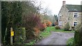
10
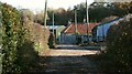
Public footpath
This photograph shows a public footpath linking Timber Lane¹ (ahead, south-easterly) with Williamthorpe Road¹ in the Highfields area of Holmewood (behind the viewpoint, northerly).
The building on the right, in front of the farm house, is a cattle barn.
For a photograph taken from the same viewpoint but facing the opposite (south-easterly) direction, click here Image
For a more south-easterly (ahead) photograph of the footpath, click here Image
For a more northerly-westerly (behind the viewpoint) photograph of the footpath, click here Image
¹ Road name information from OS Maps at:-
Elgin, http://www.elgin.gov.uk/ and the
Mapping Portal of the Derbyshire Partnership, http://derbyshiremaps.derbyshire.gov.uk/
Image: © Alan Walker
Taken: 12 Nov 2007
0.05 miles