Timber Lane
Introduction
The photograph on this page of Timber Lane by Alan Walker as part of the Geograph project.
The Geograph project started in 2005 with the aim of publishing, organising and preserving representative images for every square kilometre of Great Britain, Ireland and the Isle of Man.

There are currently over 7.5m images from over 14,400 individuals and you can help contribute to the project by visiting https://www.geograph.org.uk
Timber Lane
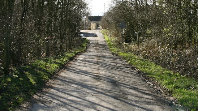
Image: © Alan Walker Taken: 9 Mar 2007
The photograph is of Timber Lane¹ (looking in a south-westerly direction) from its crossing with the Image Ahead (westerly) and on the left (hidden behind the trees but look for the shadow in the road) the lane passes a Image company. Also ahead, some of whose buildings can be seen, is Timber Lane Farm. It is at this point that the end of the metalled section of the lane is reached. The lane then continues as a footpath along the side of Broomridding Wood before ending at its junction with a bridleway to Image¹. Behind the viewpoint (easterly) Timber Lane leads to its Image¹. To see another photograph from almost the same viewpoint but looking approximately 90° anticlockwise (southerly), click here Image To see another photograph from almost the same viewpoint but looking in the opposite direction (north-easterly), click here Image For a more south-westerly (ahead) photograph of Timber Lane, click here Image For a more easterly (behind the viewpoint) photograph of Timber Lane, click here Image See also this photograph by Alan Heardman, Image ¹ Road name information from OS Maps at:- Elgin, http://www.elgin.gov.uk/ and the Mapping Portal of the Derbyshire Partnership, http://derbyshiremaps.derbyshire.gov.uk/
Images are licensed for reuse under creativecommons.org/licenses/by-sa/2.0
Image Location


Leaflet Map data © OpenStreetMap
Latitude
53.173472
Longitude
-1.362343