IMAGES TAKEN NEAR TO
Hay Lane, CHESTERFIELD, S45 0HF
Introduction
This page details the photographs taken nearby to Hay Lane, S45 0HF by members of the Geograph project.
The Geograph project started in 2005 with the aim of publishing, organising and preserving representative images for every square kilometre of Great Britain, Ireland and the Isle of Man.

There are currently over 7.5m images from over14,400 individuals and you can help contribute to the project by visiting https://www.geograph.org.uk
Image Map
Images are licensed for reuse under creativecommons.org/licenses/by-sa/2.0
Notes
- Clicking on the map will re-center to the selected point.
- The higher the marker number, the further away the image location is from the centre of the postcode.
Image Listing (16 Images Found)
Images are licensed for reuse under creativecommons.org/licenses/by-sa/2.0
Image
Details
Distance
1
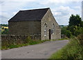
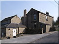
Mill Town Methodist Chapel
The church board has the name as two words, and it is away from Milltown near Ashover Hay in a quiet, rural location. It was built in 1824 and enlarged in 1870.
Image: © Andrew Hill
Taken: 24 Jul 2010
0.04 miles
2
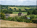
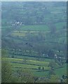
Ashover Hay view
Looking northeast from the ridge path towards the northern end. The building in the centre is the Methodist chapel as shown on the map. Beyond is the upper Amber valley with Woolley Moor on the right and Dalebank on the left.
Image: © Andrew Hill
Taken: 24 Jul 2010
0.04 miles
4
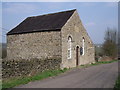
View towards Ashover Hay
Picture taken from lane in front of Raven House.
Image: © Alan Heardman
Taken: 4 Feb 2007
0.10 miles
5
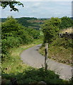
Lane corner at the end of the ridge footpath
The footpath sign is for the lovely little ridge walk at Ashover Hay.
Image: © Andrew Hill
Taken: 24 Jul 2010
0.12 miles
6
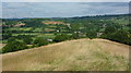
North end of the Ashover Hay ridge
This most open part of the ridge is north of the gridline - the 1:25,000 map shows an east-west wall crossing the ridge exactly on the line. The view is towards Milltown and Fallgate with the nearby quarries in sight.
Image: © Andrew Hill
Taken: 24 Jul 2010
0.12 miles
7
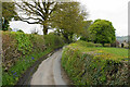
Stonerows Lane
A section of the lane with high hedgerows, not allowing much of a view.
Image: © Bill Boaden
Taken: 16 May 2021
0.13 miles
9
Milltown and Ashover Hay from Far Hill
A grainy shot taken in failing evening light, but showing the dense network of fields extending below and into the distance from the hilltop viewpoint above Farhill near Ashover.
Image: © Andrew Hill
Taken: 26 Apr 2014
0.15 miles
10
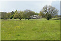
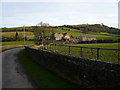
Fields below Ashover Hay
Ashover Hay rises to the left. This is a small plateau between the hill and the River Amber which is behind me.
Image: © Bill Boaden
Taken: 16 May 2021
0.16 miles