IMAGES TAKEN NEAR TO
Malthouse Lane, CHESTERFIELD, S45 0BU
Introduction
This page details the photographs taken nearby to Malthouse Lane, S45 0BU by members of the Geograph project.
The Geograph project started in 2005 with the aim of publishing, organising and preserving representative images for every square kilometre of Great Britain, Ireland and the Isle of Man.

There are currently over 7.5m images from over14,400 individuals and you can help contribute to the project by visiting https://www.geograph.org.uk
Image Map
Images are licensed for reuse under creativecommons.org/licenses/by-sa/2.0
Notes
- Clicking on the map will re-center to the selected point.
- The higher the marker number, the further away the image location is from the centre of the postcode.
Image Listing (28 Images Found)
Images are licensed for reuse under creativecommons.org/licenses/by-sa/2.0
Image
Details
Distance
1
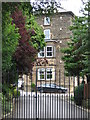
Ashover - Ashover House Hydro
Due to the security gates, this is the closest I could get to photograph the former hydro (now "apartments").
Image: © Dave Bevis
Taken: 6 Aug 2010
0.01 miles
2
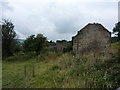
Ripe for conversion
Planning application already made for conversion of former rope house on Malthouse Lane in Rattle, a part of Ashover.
Image: © Peter Barr
Taken: 28 Jul 2010
0.11 miles
3

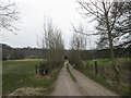
Fields and houses at the edge of Ashover
A view to the edge of the village from the footpath to Farhill.
Image: © Andrew Hill
Taken: 24 Jul 2010
0.13 miles
4
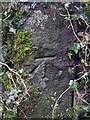
Bench mark
Close up of cut mark on Hillside, Ashover; see also Image
Image: © Andrew Hardwick
Taken: 10 Jan 2021
0.16 miles
5
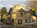
The Black Swan
The Black Swan Public House, Ashover, Derbyshire.
Image: © Dave Pickersgill
Taken: 22 Nov 2008
0.17 miles
7
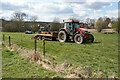
Excavator demonstration at Ashover
The excavator is just the other side of the trailer which brought it here.
Image: © Bill Boaden
Taken: 15 Apr 2021
0.17 miles
8
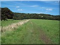
Looking towards Farhill
This picture was taken on a warm Saturday in late August. The Ashover Stone is just visible on the gritstone outcrop beyond.
Image: © Jonathan Clitheroe
Taken: 22 Aug 2009
0.18 miles
9
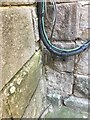
Remains of a Bench Mark
The Bench Mark on Grove House, Moor Road, Ashover has been partially hidden by a later stone buttress.
It can just be seen below and to the left of the black cable.
Image: © Andrew Hardwick
Taken: 25 Jan 2021
0.18 miles
10
Bench mark on gate post (on left)
Cut Mark on Hillside Ashover also see Image
Image: © Andrew Hardwick
Taken: 10 Jan 2021
0.19 miles