IMAGES TAKEN NEAR TO
North Road, CHESTERFIELD, S43 4PH
Introduction
This page details the photographs taken nearby to North Road, S43 4PH by members of the Geograph project.
The Geograph project started in 2005 with the aim of publishing, organising and preserving representative images for every square kilometre of Great Britain, Ireland and the Isle of Man.

There are currently over 7.5m images from over14,400 individuals and you can help contribute to the project by visiting https://www.geograph.org.uk
Image Map
Images are licensed for reuse under creativecommons.org/licenses/by-sa/2.0
Notes
- Clicking on the map will re-center to the selected point.
- The higher the marker number, the further away the image location is from the centre of the postcode.
Image Listing (26 Images Found)
Images are licensed for reuse under creativecommons.org/licenses/by-sa/2.0
Image
Details
Distance
1

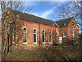
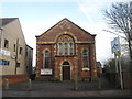
Clowne Methodist Church
A red brick chapel on North Road near the railway bridge.
Image: © Andrew Hill
Taken: 18 Nov 2010
0.02 miles
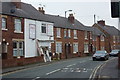
4
North Road approaching Clowne town centre
Between the railway bridge and the roundabout.
Image: © Andrew Hill
Taken: 18 Nov 2010
0.05 miles
5
The Nags Head, Clowne
An outpost of the Lancashire brewer, Thwaites lies behind the booking hall of the former Great Central Railway's station closed in 1939 - albeit the Flying Scotsman did go underneath it in 1963.
Image: © al partington
Taken: 2 Jan 2008
0.06 miles
6
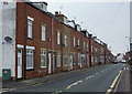
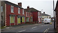
Terraced houses, North Road, Clowne
Looking past the turn for Salvin Crescent to a long terrace.
Image: © Andrew Hill
Taken: 18 Nov 2010
0.07 miles
7

Southgate Colliery memorial
On Station Road in Clowne
Image: © Stephen Ostler
Taken: 14 Sep 2022
0.08 miles

9
North Road, Clowne
Heading towards the town centre from the A616 junction.
Image: © Andrew Hill
Taken: 18 Nov 2010
0.10 miles
10

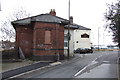
Former Clowne South station
View NE, towards Beighton and Sheffield (Victoria) (left), Langwith Junction, Shirebrook etc. right: ex-GC (Lancashire, Derbyshire & East Coast section), Beighton - Langwith branch. The line lost its passenger service (Mansfield LMS - Shirebrook North - Treeton - Sheffield LMS) from 10/9/39 and this was the booking-office. The station, which was very close to the ex-Midland station, was named Clown (no 'e') & Barlbrough, but on 18/6/51 it was renamed 'Clowne South' and the line remained open for excursions and diverted GC Main line trains as well as freight until 4/7/60.
Image: © Ben Brooksbank
Taken: 26 Aug 1983
0.11 miles