Former Clowne South station
Introduction
The photograph on this page of Former Clowne South station by Ben Brooksbank as part of the Geograph project.
The Geograph project started in 2005 with the aim of publishing, organising and preserving representative images for every square kilometre of Great Britain, Ireland and the Isle of Man.

There are currently over 7.5m images from over 14,400 individuals and you can help contribute to the project by visiting https://www.geograph.org.uk
Former Clowne South station
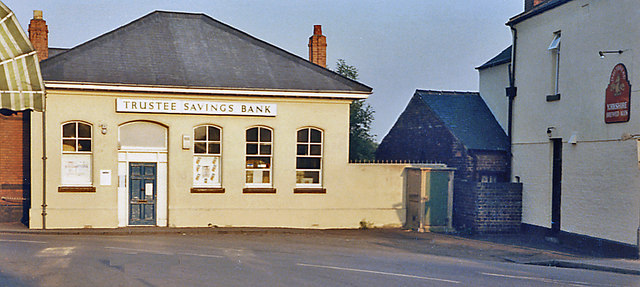
Image: © Ben Brooksbank Taken: 26 Aug 1983
View NE, towards Beighton and Sheffield (Victoria) (left), Langwith Junction, Shirebrook etc. right: ex-GC (Lancashire, Derbyshire & East Coast section), Beighton - Langwith branch. The line lost its passenger service (Mansfield LMS - Shirebrook North - Treeton - Sheffield LMS) from 10/9/39 and this was the booking-office. The station, which was very close to the ex-Midland station, was named Clown (no 'e') & Barlbrough, but on 18/6/51 it was renamed 'Clowne South' and the line remained open for excursions and diverted GC Main line trains as well as freight until 4/7/60.
Images are licensed for reuse under creativecommons.org/licenses/by-sa/2.0
Image Location
Latitude
53.275725
Longitude
-1.261547