IMAGES TAKEN NEAR TO
Highfields, CHESTERFIELD, S43 4GJ
Introduction
This page details the photographs taken nearby to Highfields, S43 4GJ by members of the Geograph project.
The Geograph project started in 2005 with the aim of publishing, organising and preserving representative images for every square kilometre of Great Britain, Ireland and the Isle of Man.

There are currently over 7.5m images from over14,400 individuals and you can help contribute to the project by visiting https://www.geograph.org.uk
Image Map
Images are licensed for reuse under creativecommons.org/licenses/by-sa/2.0
Notes
- Clicking on the map will re-center to the selected point.
- The higher the marker number, the further away the image location is from the centre of the postcode.
Image Listing (9 Images Found)
Images are licensed for reuse under creativecommons.org/licenses/by-sa/2.0
Image
Details
Distance
2
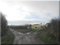
Damsbrook Lane Field
As the close horizon suggests this field sits atop a hill which falls away very steeply into the distance.
Image: © Michael Patterson
Taken: 17 Feb 2006
0.13 miles
3
Ramper Avenue
Ramper Avenue leads to Mansfield Road (where the house on the horizon is), designated the B6417 and known locally as the Ramper it is thought to be a Roman road.
Image: © Michael Patterson
Taken: 9 Feb 2006
0.14 miles
4
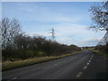
B6417 View Showing Pylon and Overhead Cables.
Image: © Alan Heardman
Taken: 24 Feb 2008
0.17 miles
5
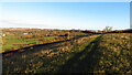
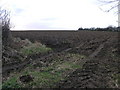
Field path running south from Clowne to Oxcroft
Image: © Colin Park
Taken: 22 Nov 2021
0.18 miles
6
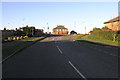
Clowne - Ramper Avenue Junction with Pitch Close
Image: © Alan Heardman
Taken: 1 Feb 2009
0.18 miles
7
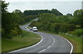
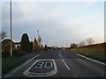
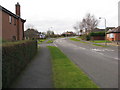
Mansfield Road south of Clowne
Looking south along the B6417 which keeps close to the highest ground between the M1 and the Trent.
Image: © Andrew Hill
Taken: 26 May 2011
0.23 miles