IMAGES TAKEN NEAR TO
Brooks Road, CHESTERFIELD, S43 2NN
Introduction
This page details the photographs taken nearby to Brooks Road, S43 2NN by members of the Geograph project.
The Geograph project started in 2005 with the aim of publishing, organising and preserving representative images for every square kilometre of Great Britain, Ireland and the Isle of Man.

There are currently over 7.5m images from over14,400 individuals and you can help contribute to the project by visiting https://www.geograph.org.uk
Image Map
Images are licensed for reuse under creativecommons.org/licenses/by-sa/2.0
Notes
- Clicking on the map will re-center to the selected point.
- The higher the marker number, the further away the image location is from the centre of the postcode.
Image Listing (22 Images Found)
Images are licensed for reuse under creativecommons.org/licenses/by-sa/2.0
Image
Details
Distance
2
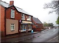
Off Licence in Barrow Hill
Birdis Off Licence and General Store pictured here on Station Road. The building behind the shop is attached to the nearby primary school.
Image: © Jonathan Clitheroe
Taken: 10 May 2012
0.11 miles
3
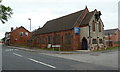
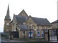
Church of St Andrew, Barrow Hill
The church dates from 1893-1895.
Image: © Andrew Hill
Taken: 10 Jun 2011
0.14 miles
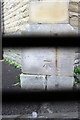
6
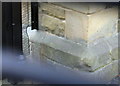
Benchmark on East angle of Barrow Hill Primary School
The school premises were locked so photo taken through perimeter fence which explains the out-of-focus bars across the image. The Ordnance Survey cut mark benchmark is described on the Bench Mark Database at http://www.bench-marks.org.uk/bm39759
Image: © Roger Templeman
Taken: 13 Oct 2011
0.16 miles
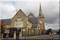
8
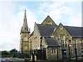
Barrow Hill primary school
An impressive looking traditional primary school with doors labelled "boys", "girls" and "infants", and also a steeple, a feature lacking from the church over the road.
Image: © Andrew Hill
Taken: 10 Jun 2011
0.17 miles
9
Benchmark on south buttress of the Primary School
The school premises Image were locked so photograph taken through its perimeter fence which explains the black bars. The Ordnance Survey cut mark benchmark is described on the Bench Mark Database at http://www.bench-marks.org.uk/bm39788
Image: © Roger Templeman
Taken: 13 Oct 2011
0.18 miles
10
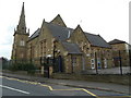
Barrow Hill Primary School with spire
Image: © Roger Templeman
Taken: 13 Oct 2011
0.18 miles