IMAGES TAKEN NEAR TO
Harewood Road, CHESTERFIELD, S42 7HT
Introduction
This page details the photographs taken nearby to Harewood Road, S42 7HT by members of the Geograph project.
The Geograph project started in 2005 with the aim of publishing, organising and preserving representative images for every square kilometre of Great Britain, Ireland and the Isle of Man.

There are currently over 7.5m images from over14,400 individuals and you can help contribute to the project by visiting https://www.geograph.org.uk
Image Map
Images are licensed for reuse under creativecommons.org/licenses/by-sa/2.0
Notes
- Clicking on the map will re-center to the selected point.
- The higher the marker number, the further away the image location is from the centre of the postcode.
Image Listing (15 Images Found)
Images are licensed for reuse under creativecommons.org/licenses/by-sa/2.0
Image
Details
Distance
1

Harewood Road - Entering Holymoorside
Image: © Alan Heardman
Taken: 17 Oct 2007
0.05 miles
2
Near Holymoorside
View taken from the lane that runs below Holy Moor.
Image: © Mike Fowkes
Taken: 22 Mar 2006
0.06 miles
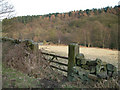
3

Harewood Road
Nab Plantation and Quarry are on the left side of the road.
Image: © Alan Heardman
Taken: 17 Oct 2007
0.06 miles
4

Valley scene near Holymoorside
Looking across the Hipper valley from the lane to wooded slopes opposite.
Image: © Andrew Hill
Taken: 16 Jun 2011
0.09 miles
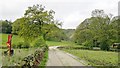
5

Bridleway outside Holymoorside
This bridleway leads from Nab Quarry down into Holymoorside.
Image: © Stephen G Taylor
Taken: 18 Apr 2009
0.16 miles
6

The Hipper valley.
Along The Chesterfield round walk.
Image: © steven ruffles
Taken: 7 May 2013
0.16 miles
7
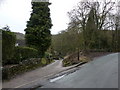
Lane/footpath off Harewood Road, Holymoorside
Pronounced "Holly" moorside, though its origins are in Holy Moor. It is not an ancient village, but developed like Cromford at the time of the introduction of cotton spinning and the factory system by Arkright and others
Image: © Peter Barr
Taken: 28 Feb 2010
0.16 miles
9
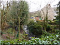
River Hipper, Holymoorside
The source of this river, which will within a few miles disappear and re-appear in the suburbs and town centre of Chesterfield, is on Beeley Moor, roundabout SK3068. The infant stream up there is called Hipper Sick. see Image
Image: © Peter Barr
Taken: 28 Feb 2010
0.17 miles
10
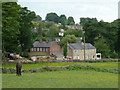
Village scene, Holymoorside
View of the southern part of the village from the path to Woodside Farm.
Image: © Andrew Hill
Taken: 16 Jun 2011
0.17 miles