IMAGES TAKEN NEAR TO
Dovetail Court, CHESTERFIELD, S41 7WE
Introduction
This page details the photographs taken nearby to Dovetail Court, S41 7WE by members of the Geograph project.
The Geograph project started in 2005 with the aim of publishing, organising and preserving representative images for every square kilometre of Great Britain, Ireland and the Isle of Man.

There are currently over 7.5m images from over14,400 individuals and you can help contribute to the project by visiting https://www.geograph.org.uk
Image Map
Images are licensed for reuse under creativecommons.org/licenses/by-sa/2.0
Notes
- Clicking on the map will re-center to the selected point.
- The higher the marker number, the further away the image location is from the centre of the postcode.
Image Listing (105 Images Found)
Images are licensed for reuse under creativecommons.org/licenses/by-sa/2.0
Image
Details
Distance
2
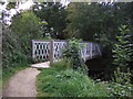
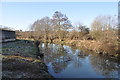
Bridge across the River Rother / Chesterfield Canal
Carrying the Trans Pennine Trail, the Cuckoo Way and the Drone Valley Way.
Image: © Christine Johnstone
Taken: 27 Aug 2012
0.03 miles
3
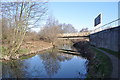
Chesterfield Canal
A concrete bridge over the canal.
Image: © Ashley Dace
Taken: 19 Mar 2011
0.03 miles
4
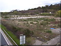
Chesterfield Waterside proposed development site
Chesterfield Waterside proposed development site as seen from a footbridge over the A61. See www.chesterfieldwaterside.com
Image: © Martin Speck
Taken: 10 Apr 2012
0.03 miles
5
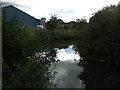
Chesterfield Canal
A view looking towards the town.
Image: © Ashley Dace
Taken: 19 Mar 2011
0.03 miles
7

New housing by the A61
Part of the Waterside Quarter built by Avant Homes. It will eventually be shielded by trees.
Image: © Bill Boaden
Taken: 3 Oct 2021
0.04 miles
9
![Bridge over the River Rother [2]](https://s3.geograph.org.uk/geophotos/03/10/39/3103923_d9115cda_120x120.jpg)
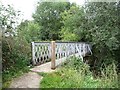
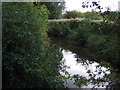
Bridge over the River Rother [2]
With the Trans Pennine Trail, Cuckoo Way and Drone Valley Way passing underneath. This part of the river forms part of the Chesterfield Canal.
Image: © Christine Johnstone
Taken: 27 Aug 2012
0.04 miles
10
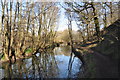
Chesterfield Canal
Trees reflect in the still waters.
Image: © Ashley Dace
Taken: 19 Mar 2011
0.04 miles