IMAGES TAKEN NEAR TO
Wharf Lane, CHESTERFIELD, S41 7NB
Introduction
This page details the photographs taken nearby to Wharf Lane, S41 7NB by members of the Geograph project.
The Geograph project started in 2005 with the aim of publishing, organising and preserving representative images for every square kilometre of Great Britain, Ireland and the Isle of Man.

There are currently over 7.5m images from over14,400 individuals and you can help contribute to the project by visiting https://www.geograph.org.uk
Image Map (Loading...)


Getting Data...Please wait
Leaflet Map data © OpenStreetMap
Images are licensed for reuse under creativecommons.org/licenses/by-sa/2.0
Notes
- Clicking on the map will re-center to the selected point.
- The higher the marker number, the further away the image location is from the centre of the postcode.
Image Listing (108 Images Found)
Images are licensed for reuse under creativecommons.org/licenses/by-sa/2.0
Image
Details
Distance
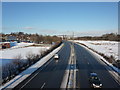
1
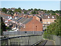
Chesterfield houses from the foot bridge
A view from the foot bridge over the main dual carriageway through Chesterfield
Image: © Chris Allen
Taken: 27 Aug 2017
0.00 miles
2
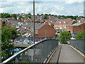
Footbridge view to Wharf Lane
View from a footbridge over the A61 to a residential area north of the town centre. The terrace line leading leftwards is on Wharf Lane.
Image: © Andrew Hill
Taken: 20 Jun 2011
0.01 miles
3
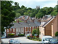
Canal Wharf towards Chesterfield town centre
New flats on the right with traditional terraces on Wharf Lane ahead. The church on the skyline is Holy Trinity on the B6051 Newbold Road.
Image: © Andrew Hill
Taken: 20 Jun 2011
0.03 miles
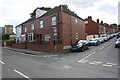
6
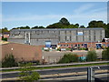
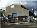
Eriks, Chesterfield
This company specialises in electrical equipment - especially motor rewinds and repairs.
Image: © Chris Allen
Taken: 27 Aug 2017
0.04 miles
8
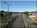
Footbridge over the A61, Chesterfield
Carries a public right of way over the main dual carriageway through Chesterfield.
Image: © Chris Allen
Taken: 27 Aug 2017
0.07 miles
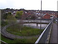
9
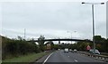
Footbridge over Rother Way, A61, Chesterfield
This leads off Wharf Lane on the west
Image: © David Smith
Taken: 20 Sep 2018
0.08 miles
10
#8 Infirmary Road at Shirland Street junction
Ordnance Survey records indicate that a benchmark levelled at 71.588m above Newlyn Datum in 1961 was present on the north angle of the house which now has brick-patterned cladding applied.
Image: © Roger Templeman
Taken: 8 Sep 2019
0.08 miles