IMAGES TAKEN NEAR TO
Lockoford Lane, CHESTERFIELD, S41 7JL
Introduction
This page details the photographs taken nearby to Lockoford Lane, S41 7JL by members of the Geograph project.
The Geograph project started in 2005 with the aim of publishing, organising and preserving representative images for every square kilometre of Great Britain, Ireland and the Isle of Man.

There are currently over 7.5m images from over14,400 individuals and you can help contribute to the project by visiting https://www.geograph.org.uk
Image Map
Images are licensed for reuse under creativecommons.org/licenses/by-sa/2.0
Notes
- Clicking on the map will re-center to the selected point.
- The higher the marker number, the further away the image location is from the centre of the postcode.
Image Listing (131 Images Found)
Images are licensed for reuse under creativecommons.org/licenses/by-sa/2.0
Image
Details
Distance
1
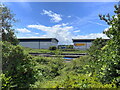
Two units in Trade Park, Lockoford Lane
Viewed from across the railway in the Sainsbury's car park.
Image: © Bill Boaden
Taken: 11 Jun 2021
0.01 miles
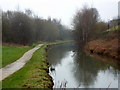
5
Chesterfield Canal
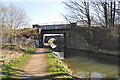
The Chesterfield canal goes under two railway lines at this point. To the south (the right in this photograph) they join together. To the north, the nearer one is the Sheffield mainline and the further one is a regional line to Killamarsh and beyond. Work on the Chesterfield canal started in October 1771 and the entire canal (which ran from Chesterfield to the River Trent north of Gainsborough) was officially opened in June 1777. The chief engineer was James Brindley but, unfortunately, he died shortly after construction began and his deputy, John Varley, was asked to take over. Subsequently the building of the canal was not without controversy. In October 1907 the Chesterfield to Norbury section was cut off from the rest of the network when the roof of Norwood Tunnel collapsed and was not reopened. Today, volunteers are working to restore the canal and there is even talk of connecting the Chesterfield to Norbury section to the South Yorkshire Navigation by making the River Rother navigable between Killamarsh and Rotherham.
Image: © Alan Walker
Taken: 5 Feb 2004
0.03 miles
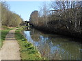
6
Chesterfield canal north of Tapton Lock
The railway bridges soon come into sight around the corner.
Image: © Andrew Hill
Taken: 5 Mar 2011
0.05 miles
7
Chesterfield Canal
A slight straight near Tapton
Image: © Ashley Dace
Taken: 19 Mar 2011
0.05 miles
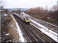
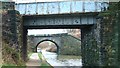
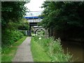
9
Chesterfield Canal - Railway Bridges
The Midland mainline and a freight line.
Image: © Ashley Dace
Taken: 19 Mar 2011
0.06 miles
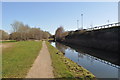
10
Three ways of travelling north of Chesterfield
The Chesterfield Canal was built to carry freight by boat. It is crossed here by two railway lines [near to Sheffield, far to Rotherham] which carry passengers and freight. The canal towpath is now used by two long distance walking and cycling routes [Trans Pennine Trail and Cuckoo Way].
Image: © Christine Johnstone
Taken: 27 Aug 2012
0.06 miles