IMAGES TAKEN NEAR TO
Highfield Terrace, Highfield Road, CHESTERFIELD, S41 7HD
Introduction
This page details the photographs taken nearby to Highfield Terrace, Highfield Road, S41 7HD by members of the Geograph project.
The Geograph project started in 2005 with the aim of publishing, organising and preserving representative images for every square kilometre of Great Britain, Ireland and the Isle of Man.

There are currently over 7.5m images from over14,400 individuals and you can help contribute to the project by visiting https://www.geograph.org.uk
Image Map
Images are licensed for reuse under creativecommons.org/licenses/by-sa/2.0
Notes
- Clicking on the map will re-center to the selected point.
- The higher the marker number, the further away the image location is from the centre of the postcode.
Image Listing (23 Images Found)
Images are licensed for reuse under creativecommons.org/licenses/by-sa/2.0
Image
Details
Distance
1
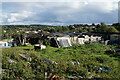
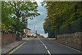
The top end of Highfield Allotments
The back of a row of sheds, which is probably not their best aspect. Some of the local undulations can be seen, and the bent spire is visible towards the right.
Image: © Bill Boaden
Taken: 3 Oct 2021
0.05 miles
2
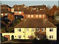
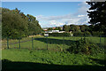
Houses in the Stonegravels area of Chesterfield
Looking across Edinburgh Park from Newbold Road
Image: © Neil Theasby
Taken: 26 Nov 2013
0.10 miles
3
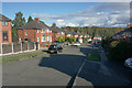
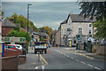
Enfield Road
A residential road in Stonegravels.
Image: © Bill Boaden
Taken: 3 Oct 2021
0.12 miles
4
Vehicle access for #58 Newbold Road
Ordnance Survey records indicate that in 1961 there was a benchmark levelled at 98.972m above Newlyn Datum on a gatepost here.
Image: © Luke Shaw
Taken: 8 Sep 2019
0.13 miles
5
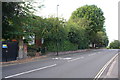
Chesterfield : Newbold Road B6051
Looking along Newbold Road.
Image: © Lewis Clarke
Taken: 1 Oct 2018
0.13 miles
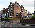
6
Christ Church (C of E) Primary School
The back entrance to the school off Highfield View Road.
Image: © Bill Boaden
Taken: 3 Oct 2021
0.17 miles
7
Newbold Road passing #48
Ordnance Survey records indicate that a benchmark levelled at 103.029m above Newlyn Datum was present in 1961 on the right hand gatepost at the house entrance. The stone gatepost appears to have been replaced by a wooden one with consequent loss of the benchmark
Image: © Luke Shaw
Taken: 8 Sep 2019
0.18 miles
8

Benchmark on wall outside #28 Gladstone Road
Ordnance Survey cut mark benchmark levelled at 98.972m above Newlyn Datum in 1961
Image: © Luke Shaw
Taken: 8 Sep 2019
0.18 miles
9

#28 Gladstone Road
There is an OS benchmark Image on the brick wall
Image: © Luke Shaw
Taken: 8 Sep 2019
0.18 miles
10
Chesterfield : Newbold Road B6051
Looking along Newbold Road.
Image: © Lewis Clarke
Taken: 1 Oct 2018
0.19 miles