IMAGES TAKEN NEAR TO
Hawksley Avenue, CHESTERFIELD, S40 4TQ
Introduction
This page details the photographs taken nearby to Hawksley Avenue, S40 4TQ by members of the Geograph project.
The Geograph project started in 2005 with the aim of publishing, organising and preserving representative images for every square kilometre of Great Britain, Ireland and the Isle of Man.

There are currently over 7.5m images from over14,400 individuals and you can help contribute to the project by visiting https://www.geograph.org.uk
Image Map
Images are licensed for reuse under creativecommons.org/licenses/by-sa/2.0
Notes
- Clicking on the map will re-center to the selected point.
- The higher the marker number, the further away the image location is from the centre of the postcode.
Image Listing (43 Images Found)
Images are licensed for reuse under creativecommons.org/licenses/by-sa/2.0
Image
Details
Distance
1
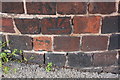
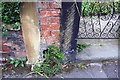
Benchmark on wall outside #2 Cromwell Road at Hawksley Avenue junction
Ordnance Survey cut mark benchmark levelled at 112.304m above Newlyn Datum in 1961. The mark is inverted which may mean be the wall has been rebuilt since the mark was cut.
Image: © Roger Templeman
Taken: 8 Sep 2019
0.02 miles
2
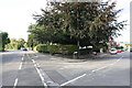
Junction of Hawksley Avenue and Cromwell Road
There is an OS benchmark Image on the brick wall at the corner about 2 feet left of the road name sign
Image: © Roger Templeman
Taken: 8 Sep 2019
0.04 miles
3
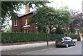
No. 16 Gladstone Road ('Russell House')
Ordnance Survey records indicate that a benchmark levelled at 109.770m above Newlyn Datum was present on the wall in 1961. The bottom section of the wall is pebbledashed with 3 brick courses added above resulting in the possible loss of the mark.
Image: © Roger Templeman
Taken: 8 Sep 2019
0.08 miles
4

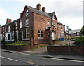
#28 Gladstone Road
There is an OS benchmark Image on the brick wall
Image: © Luke Shaw
Taken: 8 Sep 2019
0.10 miles
5

Benchmark on wall outside #28 Gladstone Road
Ordnance Survey cut mark benchmark levelled at 98.972m above Newlyn Datum in 1961
Image: © Luke Shaw
Taken: 8 Sep 2019
0.11 miles
6
Vehicle access for #58 Newbold Road
Ordnance Survey records indicate that in 1961 there was a benchmark levelled at 98.972m above Newlyn Datum on a gatepost here.
Image: © Luke Shaw
Taken: 8 Sep 2019
0.13 miles
7
End of party wall between Nos. 28 and 30 Cobden Road
Ordnance Survey records indicate that in 1961 there was a benchmark levelled at 107.412m above Newlyn Datum on this wall junction. The brickwork is now weathered and no mark was evident.
Image: © Roger Templeman
Taken: 8 Sep 2019
0.13 miles
8
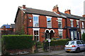
Cobden Road houses
There was an OS benchmark Image on the wall junction left of the left hand gatepost at the entrance to the nearest house
Image: © Roger Templeman
Taken: 8 Sep 2019
0.13 miles
9
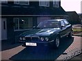
Marchwood Close Jaguar
A wonderful childhood memory. L24 UGT a 1994 3.2S XJ40 XJ6 basking in the summer sun, awaiting her new owner.
Image: © Jason Walker
Taken: Unknown
0.14 miles
10
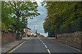
Chesterfield : Newbold Road B6051
Looking along Newbold Road.
Image: © Lewis Clarke
Taken: 1 Oct 2018
0.14 miles