IMAGES TAKEN NEAR TO
Manchester Road, SHEFFIELD, S36 9FG
Introduction
This page details the photographs taken nearby to Manchester Road, S36 9FG by members of the Geograph project.
The Geograph project started in 2005 with the aim of publishing, organising and preserving representative images for every square kilometre of Great Britain, Ireland and the Isle of Man.

There are currently over 7.5m images from over14,400 individuals and you can help contribute to the project by visiting https://www.geograph.org.uk
Image Map
Images are licensed for reuse under creativecommons.org/licenses/by-sa/2.0
Notes
- Clicking on the map will re-center to the selected point.
- The higher the marker number, the further away the image location is from the centre of the postcode.
Image Listing (6 Images Found)
Images are licensed for reuse under creativecommons.org/licenses/by-sa/2.0
Image
Details
Distance
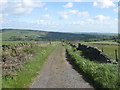
1
Green House Farm
On the A628 Manchester Road
Image: © Graham Hogg
Taken: 7 Jul 2014
0.07 miles
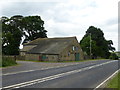
2
Pennine industry
This industrial site is located in located amidst the Pennine greenery alongside the A628 Manchester Road at Bullhouse. I believe it occupies the former site of Bullhouse Colliery which closed in 1918.
Image: © Bobby Clegg
Taken: 12 Jun 2014
0.14 miles

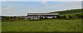
4
Bullhouse Minewater Project
Water running out of old mineworkings can contain high levels of ochre, turning the water orange and killing all plant life. Here the water is pumped into a large settling lagoon to allow the ochre to settle before allowing clear water to be siphoned off and flow downstream.
All part of the legacy that needs managing in old coalfield areas. In this case the colliery closed in 1918, but the adit still brings this ochre laden water to the surface.
Image: © Chris Morgan
Taken: 7 Jul 2014
0.20 miles
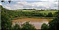
5
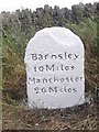
Old Milestone by the A628, Manchester Road, Penistone parish
Carved stone post by the A628, in parish of Penistone (Barnsley District), Manchester Road, North of right angled bend at Fullshaw Cross Roads, 150m North of junction with Hartcliff Road, on banking 20m North of gate, 40m North of bend sign, on East side of road. Erected by the Doncaster & Salter's Brook turnpike trust in the 18th century.
Inscription reads:-
Barnsley
10 Miles
Manchester
26 Miles
Grade II listed.
List Entry Number: 1151819 https://historicengland.org.uk/listing/the-list/list-entry/1151819
Milestone Society National ID: YS_BNMC10
Image: © C Minto
Taken: 1 Mar 1993
0.21 miles