IMAGES TAKEN NEAR TO
Oxspring Road, SHEFFIELD, S36 8FN
Introduction
This page details the photographs taken nearby to Oxspring Road, S36 8FN by members of the Geograph project.
The Geograph project started in 2005 with the aim of publishing, organising and preserving representative images for every square kilometre of Great Britain, Ireland and the Isle of Man.

There are currently over 7.5m images from over14,400 individuals and you can help contribute to the project by visiting https://www.geograph.org.uk
Image Map
Images are licensed for reuse under creativecommons.org/licenses/by-sa/2.0
Notes
- Clicking on the map will re-center to the selected point.
- The higher the marker number, the further away the image location is from the centre of the postcode.
Image Listing (10 Images Found)
Images are licensed for reuse under creativecommons.org/licenses/by-sa/2.0
Image
Details
Distance
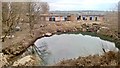
3
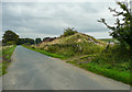
Spoil heap. Oxspring Road, Penistone
It is not clear from old maps why this heap is here. There were some old shafts in the area, but also the 1905 1:2500 map shows what looks like a pond excavated adjacent to the heap.
Image: © Humphrey Bolton
Taken: 10 Sep 2020
0.12 miles
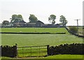
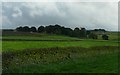
4
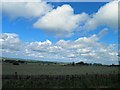
Roughbirchwood Common
A view from New Lodge; moles very active on this mild, bright January day. The tree in the centre of the photograph clearly takes the brunt of the prevailing winds. The name 'common' reflects the site's history - now the landscape is intersected by post-enclosure dry-stone walls.
Image: © Chris Yeates
Taken: 21 Jan 2006
0.15 miles
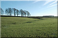
5
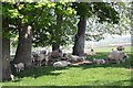
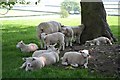
Sunshine sheltering sheep close to New House
Image: © Neil Theasby
Taken: 23 May 2012
0.20 miles
7
Two interesting houses at Racecommon Quarry
Being built on the site of an old quarry, they will be sheltered from prevailing south westerly winds, but won't get much view, except of the deep lake left by the quarry.
Image: © Chris Morgan
Taken: 21 Mar 2016
0.23 miles
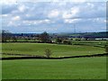
8
Dry stone wall boundaries
Here this side of the dry stone walls are a rich mossy green as they all face north. New Lodge Farm can be seen in the distance under this grey and stormy sky.
Image: © Wendy North
Taken: 19 Aug 2008
0.23 miles
10
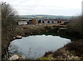
'Earth sheltered dwellings' under construction
Two single storey dwellings overlooking an old stone quarry
Image: © Graham Hogg
Taken: 21 Mar 2016
0.24 miles