IMAGES TAKEN NEAR TO
Carr Head Lane, SHEFFIELD, S36 7GA
Introduction
This page details the photographs taken nearby to Carr Head Lane, S36 7GA by members of the Geograph project.
The Geograph project started in 2005 with the aim of publishing, organising and preserving representative images for every square kilometre of Great Britain, Ireland and the Isle of Man.

There are currently over 7.5m images from over14,400 individuals and you can help contribute to the project by visiting https://www.geograph.org.uk
Image Map
Images are licensed for reuse under creativecommons.org/licenses/by-sa/2.0
Notes
- Clicking on the map will re-center to the selected point.
- The higher the marker number, the further away the image location is from the centre of the postcode.
Image Listing (26 Images Found)
Images are licensed for reuse under creativecommons.org/licenses/by-sa/2.0
Image
Details
Distance
1
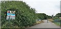
Peak Venture
Outdoor Centre all closed down; https://www.kingswood.co.uk/activity-centres/peak-venture/
Image: © Chris Morgan
Taken: 9 Jun 2020
0.11 miles
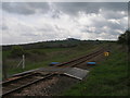
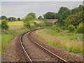
2
Level crossing near Carr Lodge Farm
The track crossing the railway here is a bridleway, hence the provision of mounting blocks for horse riders
Image: © John Slater
Taken: 7 May 2012
0.14 miles
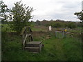
3
Level crossing north of Carr Lodge Farm
The blue covers are access to drainage
Image: © John Slater
Taken: 7 May 2012
0.14 miles
4

Crossing the track
Railway from Barnsley to Huddersfield
Image: © Chris Morgan
Taken: 9 Jun 2020
0.15 miles

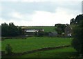
6
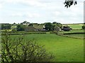
Carr Head Farm with railway embankment behind
Image: © Wendy North
Taken: 23 Aug 2008
0.17 miles
7
The Barnsley to Huddersfield railway
At a bridleway level crossing at Carr Head
Image: © Graham Hogg
Taken: 9 Jun 2020
0.17 miles
8
Train en-route from Penistone to Huddersfield
Photograph taken from Carr Lane Farm. This is a journey we keep promising ourselves as the views are said to be very spectacular. See http://www.penline.co.uk/
Image: © Wendy North
Taken: 23 Aug 2008
0.17 miles
10
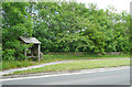
Bus shelter on the A629, Penistone
Very convenient for the entrance to Scout Dyke Reservoir, and the Scout Dike Outdoor Recreation Centre.
Image: © Humphrey Bolton
Taken: 13 Jun 2020
0.20 miles