IMAGES TAKEN NEAR TO
Woodkirk Close, SHEFFIELD, S36 6HW
Introduction
This page details the photographs taken nearby to Woodkirk Close, S36 6HW by members of the Geograph project.
The Geograph project started in 2005 with the aim of publishing, organising and preserving representative images for every square kilometre of Great Britain, Ireland and the Isle of Man.

There are currently over 7.5m images from over14,400 individuals and you can help contribute to the project by visiting https://www.geograph.org.uk
Image Map
Images are licensed for reuse under creativecommons.org/licenses/by-sa/2.0
Notes
- Clicking on the map will re-center to the selected point.
- The higher the marker number, the further away the image location is from the centre of the postcode.
Image Listing (21 Images Found)
Images are licensed for reuse under creativecommons.org/licenses/by-sa/2.0
Image
Details
Distance
1
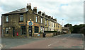
Caf? and houses, Sheffield Road, Penistone
The café was closed due to the virus pandemic.
Image: © Humphrey Bolton
Taken: 3 Sep 2020
0.09 miles
2
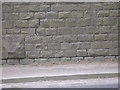
Benchmark on the high wall near Kirkwood Bridge
For a wider view of the location, see Image
Image: © John Slater
Taken: 31 Mar 2012
0.11 miles
3
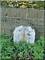
Old Boundary Marker by the B6462, Sheffield Road, Penistone Parish
Parish Boundary Marker by the B6462, in parish of Penistone (Barnsley District), Sheffield Road, Spring Vale, road bridge over Kirkwood Beck against South West parapet.
Surveyed
Milestone Society National ID: YW_PENRPENU01pb
Image: © Milestone Society
Taken: Unknown
0.11 miles
4
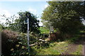
Emerging onto the Trans Pennine Trail
At this point the Barnsley, Penistone, Huddersfield line runs alongside this section of disused rail track - now the Trans Pennine Trail.
Image: © Wendy North
Taken: 19 Aug 2008
0.12 miles
5
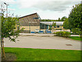
Springvale Primary School. Penistone
Image: © Humphrey Bolton
Taken: 3 Sep 2020
0.13 miles
6
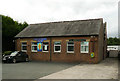
Shared church, Sheffield Road, Penistone
This is the Methodist Church, but is also used by the Penistone Community Church. The 1929 1:2500 map shows a Primitive Methodist Church here, not shown on the previous, 1907 edition. You can see a little of this older building behind the modern one.
Image: © Humphrey Bolton
Taken: 3 Sep 2020
0.14 miles
7
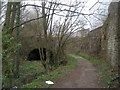
Track and Kirkwood Beck head under the railway
Image: © John Slater
Taken: 31 Mar 2012
0.16 miles
8
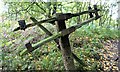
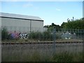
Railway infrastructure remnants
Railway infrastructure remnants close to the Trans Pennine Trail (TPT) at Oxspring.
Image: © Dave Pickersgill
Taken: 6 Oct 2022
0.17 miles
9
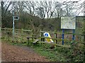
Footpath junction on the Trans Pennine Trail
With a helpfully located traffic bollard to keep you on the correct side of the path!
Image: © Graham Hogg
Taken: 18 Jan 2012
0.17 miles