IMAGES TAKEN NEAR TO
Chapel Field Lane, SHEFFIELD, S36 6FS
Introduction
This page details the photographs taken nearby to Chapel Field Lane, S36 6FS by members of the Geograph project.
The Geograph project started in 2005 with the aim of publishing, organising and preserving representative images for every square kilometre of Great Britain, Ireland and the Isle of Man.

There are currently over 7.5m images from over14,400 individuals and you can help contribute to the project by visiting https://www.geograph.org.uk
Image Map
Images are licensed for reuse under creativecommons.org/licenses/by-sa/2.0
Notes
- Clicking on the map will re-center to the selected point.
- The higher the marker number, the further away the image location is from the centre of the postcode.
Image Listing (14 Images Found)
Images are licensed for reuse under creativecommons.org/licenses/by-sa/2.0
Image
Details
Distance
1
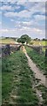
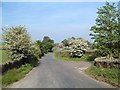
View of footpath next to Sike Farm
View towards Sike Farm
Image: © Wendy Broadhead
Taken: 9 May 2020
0.09 miles
4
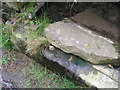
Rivet benchmark on the trough at New Chapel
Image: © John Slater
Taken: 5 May 2012
0.18 miles
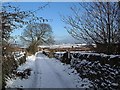
5
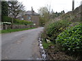
Road at New Chapel
The trough on the right is the location of Image
Image: © John Slater
Taken: 5 May 2012
0.18 miles
6
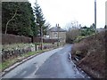
Entering Penistone from Hartcliffe Road
At the bend in the road ahead Hartcliffe Road becomes Chapel Lane. The dwelling in the centre of shot is the Stables, dating from 1717 according to an inscription above the window. Note also the stone trough by the road on the right.
Image: © Jonathan Clitheroe
Taken: 22 Feb 2011
0.19 miles
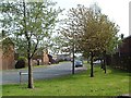
9
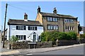
Penistone houses - corner of Clarel St & High St
Image: © Neil Theasby
Taken: 23 May 2012
0.23 miles
10
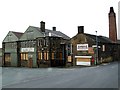
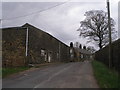
The junction of Green Road and The Green
An old factory disused.
Image: © John Fielding
Taken: 28 Jun 2007
0.23 miles