IMAGES TAKEN NEAR TO
Green Road, SHEFFIELD, S36 6BH
Introduction
This page details the photographs taken nearby to Green Road, S36 6BH by members of the Geograph project.
The Geograph project started in 2005 with the aim of publishing, organising and preserving representative images for every square kilometre of Great Britain, Ireland and the Isle of Man.

There are currently over 7.5m images from over14,400 individuals and you can help contribute to the project by visiting https://www.geograph.org.uk
Image Map
Images are licensed for reuse under creativecommons.org/licenses/by-sa/2.0
Notes
- Clicking on the map will re-center to the selected point.
- The higher the marker number, the further away the image location is from the centre of the postcode.
Image Listing (26 Images Found)
Images are licensed for reuse under creativecommons.org/licenses/by-sa/2.0
Image
Details
Distance
1
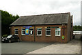
Shared church, Sheffield Road, Penistone
This is the Methodist Church, but is also used by the Penistone Community Church. The 1929 1:2500 map shows a Primitive Methodist Church here, not shown on the previous, 1907 edition. You can see a little of this older building behind the modern one.
Image: © Humphrey Bolton
Taken: 3 Sep 2020
0.06 miles
2
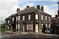
Hinchliff Butcher
Traditional butcher's shop and premises on Sheffield Road http://www.geograph.org.uk/photo/2073877 now closed and boarded up
Image: © Richard Croft
Taken: 11 Sep 2010
0.06 miles
3
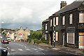
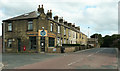
Sheffield Road
Penistone street scene
Image: © Richard Croft
Taken: 11 Sep 2010
0.06 miles
4
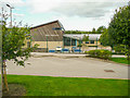
Springvale Primary School. Penistone
Image: © Humphrey Bolton
Taken: 3 Sep 2020
0.07 miles
5
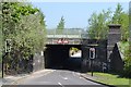
Green Road, Penistone - Bridge under the railway
Image: © Neil Theasby
Taken: 23 May 2012
0.09 miles
7
Caf? and houses, Sheffield Road, Penistone
The café was closed due to the virus pandemic.
Image: © Humphrey Bolton
Taken: 3 Sep 2020
0.14 miles
8
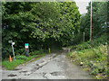
Footpath on driveway to Springvale Physic Garden, Penistone
Image: © Humphrey Bolton
Taken: 3 Sep 2020
0.15 miles
9
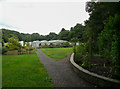
Springvale Physic Garden, Penistone
"Penistone Physic Garden was built and planted during the summer of 2008. It is on part of the site of the former Rainbow Plants nursery next to the River Don in Springvale, Penistone, and is the first new project in the regeneration of the whole three acre site. Penistone Physic Garden is a herb garden of mainly medicinal, but also culinary and other useful plants." (from the website www.springvaleonline.com/physic.html )
Image: © Humphrey Bolton
Taken: 3 Sep 2020
0.16 miles
10
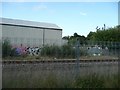
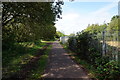
Emerging onto the Trans Pennine Trail
At this point the Barnsley, Penistone, Huddersfield line runs alongside this section of disused rail track - now the Trans Pennine Trail.
Image: © Wendy North
Taken: 19 Aug 2008
0.17 miles