IMAGES TAKEN NEAR TO
Church View Crescent, SHEFFIELD, S36 6AS
Introduction
This page details the photographs taken nearby to Church View Crescent, S36 6AS by members of the Geograph project.
The Geograph project started in 2005 with the aim of publishing, organising and preserving representative images for every square kilometre of Great Britain, Ireland and the Isle of Man.

There are currently over 7.5m images from over14,400 individuals and you can help contribute to the project by visiting https://www.geograph.org.uk
Image Map
Images are licensed for reuse under creativecommons.org/licenses/by-sa/2.0
Notes
- Clicking on the map will re-center to the selected point.
- The higher the marker number, the further away the image location is from the centre of the postcode.
Image Listing (159 Images Found)
Images are licensed for reuse under creativecommons.org/licenses/by-sa/2.0
Image
Details
Distance
1
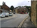
Sheffield Road, Penistone
Penistone railway station lies just to the right under the railway bridge.
Image: © Benjamin Hopkins
Taken: 20 Jul 2010
0.02 miles


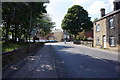
4

Trans Pennine Trail in Penistone
Tomorrow the 13th September is the trail's 25th anniversary.
Image: © Steve Fareham
Taken: 12 Sep 2014
0.09 miles
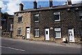
6

Shrewsbury Road, Penistone
Looking out of the town centre on the B6462.
Image: © Stephen McKay
Taken: 10 Jul 2016
0.09 miles
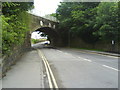
7
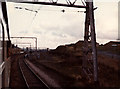
Approaching Penistone station
The former Woodhead railway line as it approaches Penistone from the west, with Eastfield Avenue alongside the railway to the right.
The train was a private charter for members of the Oxford University Railway Society, a few months before the line finally closed.
I had tried before to locate this photo from my archive, believing it was at the other end of the line around Hadfield, but finally placed it here by locating the houses with the help of aerial photography on the Wheres-the-Path website.
Image: © Stephen Craven
Taken: 14 Dec 1980
0.09 miles