IMAGES TAKEN NEAR TO
Dunford Bridge, SHEFFIELD, S36 4AF
Introduction
This page details the photographs taken nearby to S36 4AF by members of the Geograph project.
The Geograph project started in 2005 with the aim of publishing, organising and preserving representative images for every square kilometre of Great Britain, Ireland and the Isle of Man.

There are currently over 7.5m images from over14,400 individuals and you can help contribute to the project by visiting https://www.geograph.org.uk
Image Map (Loading...)


Getting Data...Please wait
Leaflet Map data © OpenStreetMap
Images are licensed for reuse under creativecommons.org/licenses/by-sa/2.0
Notes
- Clicking on the map will re-center to the selected point.
- The higher the marker number, the further away the image location is from the centre of the postcode.
Image Listing (139 Images Found)
Images are licensed for reuse under creativecommons.org/licenses/by-sa/2.0
Image
Details
Distance
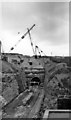
2
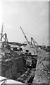
Construction of New Woodhead Tunnel, August 1952
View westward, towards Manchester, of the new bore, as seen from Dunford Bridge road bridge.
Image: © Walter Dendy, deceased
Taken: 17 Aug 1952
0.01 miles
3
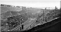
Woodhead Tunnels, east portals 1950
View westward towards Manchester from Dunford Bridge: the twin old Tunnels are in centre, the new cutting and tunnel under construction on the left.
Image: © Walter Dendy, deceased
Taken: 8 Oct 1950
0.01 miles
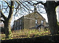
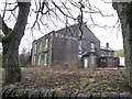
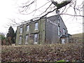
6
Stanhope
The disused Stanhope Hotel at Dunsford Bridge.
Image: © Peter McDermott
Taken: 27 Jun 2015
0.01 miles
7
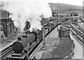
Down freight passing Dunford Bridge station just before opening of New Woodhead Tunnel
View eastward, towards Penistone and Sheffield/Wath: ex-GC Manchester - Sheffield/Wath via Woodhead main line, just five days before the old station and Tunnels were opened on the newly-electrified route. (See also other images at Dunford Bridge). The Class J Down mineral is headed by O4/8 2-8-0 No. 63853, LNER No. 6292 from acquisition in 1/24 until renumbered 3853 in 1946: it was built as ROD No. 2055 to Government order in 6/19, never went to France and was purchased by the LNWR in 9/19 (No. 2851), returned to the Government in 8/21 and stored at Queensferry until 1/24; it was rebuilt to O4/8 in 5/44 and eventually withdrawn in 11/63 as No. 63853.
Image: © Ben Brooksbank
Taken: 9 Jun 1954
0.01 miles
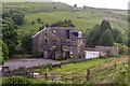
8
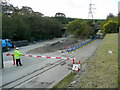
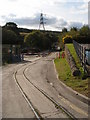
Old railway line at Dunford Bridge
Looking towards the twin road bridge over the old Sheffield to Manchester railway.
Viewed from the Don Trail car park.
Image: © Jonathan Billinger
Taken: 8 Oct 2009
0.01 miles
9
New Woodhead Tunnel: eastern (Dunford) portal, 1953
View westward, towards Manchester, from road at Dunford Bridge, in later stages of construction.
Image: © Walter Dendy, deceased
Taken: 2 Aug 1953
0.02 miles