IMAGES TAKEN NEAR TO
Bevan Way, SHEFFIELD, S35 1RN
Introduction
This page details the photographs taken nearby to Bevan Way, S35 1RN by members of the Geograph project.
The Geograph project started in 2005 with the aim of publishing, organising and preserving representative images for every square kilometre of Great Britain, Ireland and the Isle of Man.

There are currently over 7.5m images from over14,400 individuals and you can help contribute to the project by visiting https://www.geograph.org.uk
Image Map
Images are licensed for reuse under creativecommons.org/licenses/by-sa/2.0
Notes
- Clicking on the map will re-center to the selected point.
- The higher the marker number, the further away the image location is from the centre of the postcode.
Image Listing (21 Images Found)
Images are licensed for reuse under creativecommons.org/licenses/by-sa/2.0
Image
Details
Distance
1
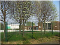
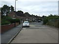
Windmill Hill Primary School, Burncross
Image: © Oxana Maher
Taken: 14 Apr 2007
0.11 miles
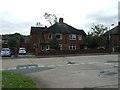
5
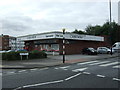
Post Office and stores, Burncross
On Burncross Road (B6546).
The number of this road is incorrectly shown as the B113 on some maps see https://www.sabre-roads.org.uk/wiki/index.php?title=B113_(Chapeltown)
Image: © JThomas
Taken: 27 Sep 2014
0.18 miles
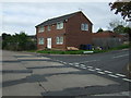
6
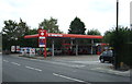
Service station on Burncross Road (B6546)
The number of this road is incorrectly shown as the B113 on some maps see https://www.sabre-roads.org.uk/wiki/index.php?title=B113_(Chapeltown)
Image: © JThomas
Taken: 27 Sep 2014
0.18 miles
7
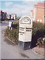
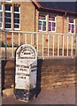
Old Milestone, on the A629, ? mile W of Chapeltown centre
On Burncross Road. Located on the North side of road, at entrance to Burncross Drive. Metal plate attached to stone post, Brayshaw & Booth casting design, 19th century. More recently a low, faux limestone wall has been built behind the milestone. View before the housing estate was built see http://www.geograph.org.uk/photo/6742561
Inscription reads: ROTHERHAM / 6 MILES / CHAPELTOWN / ½ MILE // PENISTONE / 8¼ MILES // ROTHERHAM WORTLEY & FOUR / LANE ENDS / ROAD / CHAPELTOWN // BRAYSHAW & BOOTH / MAKERS / LIVERSEDGE
Grade II listed by Historic England. see https://historicengland.org.uk/listing/the-list/list-entry/1132828
Milestone Society National ID: YS_RMWT06
Image: © Christine Minto
Taken: Unknown
0.19 miles
8
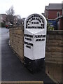
Old Milestone, A629, ? mile W of Chapeltown centre
On Burncross Road. Located on the North side of road, at entrance to Burncross Drive. Metal plate attached to stone post, Brayshaw & Booth casting design, 19th century. Image taken before the school closed and was demolished. Date approximately 1994 for a later view see https://www.geograph.org.uk/photo/6742081
Inscription reads: ROTHERHAM / 6 MILES / CHAPELTOWN / ½ MILE // PENISTONE / 8¼ MILES // ROTHERHAM WORTLEY & FOUR / LANE ENDS / ROAD / CHAPELTOWN // BRAYSHAW & BOOTH / MAKERS / LIVERSEDGE
Grade II listed by Historic England. see https://historicengland.org.uk/listing/the-list/list-entry/1132828
Milestone Society National ID: YS_RMWT06
Image: © Christine Minto
Taken: Unknown
0.19 miles
9
Old milestone
About ½ mile from the centre of Chapeltown on Burncross Road at Burncross Drive. This West Riding CC stone from 1893/94 is shown to the full height of the attachment. There will be another 20cm of stone under pavement level. All 4 fixing points can be seen. There is a hole in the top for previous use by Ordnance Survey. It was in front of a school building which was demolished, houses were built and the stone slightly repositioned. It is grade II listed 335445.
Image: © Chris Minto
Taken: 3 Mar 2019
0.19 miles