IMAGES TAKEN NEAR TO
Manor Road, SHEFFIELD, S26 6PD
Introduction
This page details the photographs taken nearby to Manor Road, S26 6PD by members of the Geograph project.
The Geograph project started in 2005 with the aim of publishing, organising and preserving representative images for every square kilometre of Great Britain, Ireland and the Isle of Man.

There are currently over 7.5m images from over14,400 individuals and you can help contribute to the project by visiting https://www.geograph.org.uk
Image Map
Images are licensed for reuse under creativecommons.org/licenses/by-sa/2.0
Notes
- Clicking on the map will re-center to the selected point.
- The higher the marker number, the further away the image location is from the centre of the postcode.
Image Listing (45 Images Found)
Images are licensed for reuse under creativecommons.org/licenses/by-sa/2.0
Image
Details
Distance
1
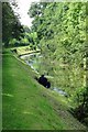
Fat Man Fishing
He has cast his line in Chesterfield Canal, not far from Kiveton Park Station on a sultry summer's afternoon.
Image: © Neil Theasby
Taken: 25 Jul 2014
0.12 miles
2
Filling up the canal
After a few days of heavy rain, water is pouring into the Chesterfield Canal. The feeder comes north and then east from Harthill and Pebley Reservoirs.
Image: © Christine Johnstone
Taken: 31 Mar 2010
0.13 miles
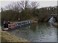
3
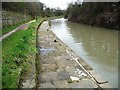
Moorings on the Chesterfield Canal
The moorings are for the winding hole at the end of the navigable section of the canal from the River Trent to Norwood. After a very rainy April there was a lot of water entering the canal here from the supply reservoirs to the south.
Image: © Graham Hogg
Taken: 30 Apr 2012
0.13 miles
4
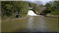
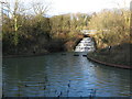
Chesterfield Canal Feeder at Kiveton Park Station
Nb "Tamara 2” reaches the Manor Road winding hole at Kiveton Park Station (the current head of navigation) where the feeder from Harthill Reservoir runs into the Chesterfield Canal. Winding holes such as this are provided at strategic points along the canal for turning boats, which are generally longer than the canal is wide. Here, “Tamara 2” demonstrates how these winding holes are used. Canal arms and junctions can also be used to similar effect.
Image: © Mike Nield
Taken: 13 Apr 2013
0.13 miles
5
Moorings on the Chesterfield Canal
This mooring has been installed because the current head of navigation is just around the bend.
Image: © Christine Johnstone
Taken: 31 Mar 2010
0.14 miles
6
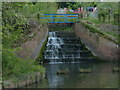
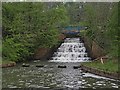
Weir on sluice supplying water to Chesterfield Canal at Kiveton Park
On this day there was a lot more water flowing into the canal than usual, so lower down another weir allowed excess water to flow out again.
The Chesterfield canal is navigable from the River Trent to here. It was restored quite recently, but just to the left of this point lies a tunnel that's been collapsed for 100 years after mining subsidence. It may take a few years to get through there and finally on to Chesterfield.
Image: © Chris Morgan
Taken: 30 Apr 2012
0.14 miles
7
Feeder at the Manor Road Winding Hole
The feeder is providing water to the Chesterfield Canal from the Harthill Reservoir.
Image: © Mat Fascione
Taken: 22 May 2016
0.14 miles
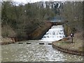
8
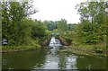
Chesterfield Canal Feeder at Kiveton Park Station
The Harthill Feeder, perhaps more commonly known as the Manor Road Feeder, is situated by the Manor Road winding hole near Kiveton Park Station. The water is taken from Pebley and Harthill Reservoirs on the South Yorkshire/north-east Derbyshire border and flows via the Broad Bridge Dike before finally tumbling down the cascade and into the canal.
This view was taken in early September, 2017. At this time of year the water flowing down the cascade would normally be reduced to little more than a trickle, but after a wetter than usual summer the fall was more impressive, though still not in full force.
Image: © Mike Nield
Taken: 4 Sep 2017
0.14 miles
9
Chesterfield Canal Feeder at Kiveton Park Station
The Harthill Feeder (sometimes known as the Manor Road feeder) is situated by the Manor Road winding hole close to Kiveton Park Station and takes its water from Harthill Reservoir. This view, taken in May 2012, shows the falls in full spate after a winter of heavy rain. In a normal summer it is usually reduced to a mere trickle.
Image: © Mike Nield
Taken: 1 May 2012
0.14 miles
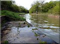
10
Kiveton Park - Chesterfield Canal inlet
The feeder stream from Harthill Reservoir joins the Chesterfield Canal at this point.
Image: © Dave Bevis
Taken: 12 Dec 2009
0.15 miles