1
Wales - Wales Road
Shops, banks and building societies.
Image: © Alan Heardman
Taken: 27 Jan 2009
0.04 miles
2
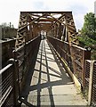
Pedestrian Footbridge near Kiveton Bridge Station
Image: © Alan Heardman
Taken: 27 Jan 2009
0.08 miles
3
Pedestrian Footbridge near Kiveton Bridge Station
Image: © Alan Heardman
Taken: 27 Jan 2009
0.08 miles
4
Kiveton Bridge Station Footbridge
Kiveton Park, South Yorkshire
Seen here from the top of the steps at the Station Road end of the bridge, looking towards Colliery Road.
When Kiveton Bridge Station opened in July 1929, passenger access to the two platforms was through the booking office, which was adjacent to the main road. Access to Platform 2 (for Sheffield-bound trains) was then by this overbridge. In the early 1970s the station was modernised and became destaffed. The booking hall was demolished but the footbridge remained and now serves not only passenger access across the line but general pedestrian access onto Colliery Road, avoiding the narrow walkway across the busy road bridge.
Flickr: https://www.flickr.com/photos/128783627@N03/38353692211/in/photostream/
Image: © Mike Nield
Taken: 25 Sep 2017
0.09 miles
5
Kiveton Bridge and Station Footbridge
Kiveton Park, South Yorkshire.
"Kiveton Bridge" properly refers to the road bridge from which the adjacent railway station takes its name. When the station opened in July 1929, passenger access to the two platforms was through the booking office, which was adjacent to the main road. Access to Platform 2 (for Sheffield-bound trains) was provided for by this overbridge. In the early 1970s the station was modernised and became destaffed. The now-redundant booking hall was subsequently demolished, but the footbridge remained and now serves not only passenger access across the line but general pedestrian access too, enabling them to avoid the narrow walkway across the road bridge.
This photo is taken from the end of Platform 2 on Kiveton Bridge station, on the Down line looking towards Sheffield, and is as close as it's possible to get to photograph the bridge without going off the end of the platform and trespassing on the permanent way. An alternative view can be had by crossing the footbridge and peering through the latticed side.
Flickr: https://www.flickr.com/photos/128783627@N03/38327911802/in/photostream/
Image: © Mike Nield
Taken: 20 Sep 2017
0.09 miles
6
Kiveton Bridge
Kiveton Park, South Yorkshire.
Kiveton Bridge (from which the adjacent railway station takes its name) is described as a single span skew-arched bridge accommodating road over railway. It was built by engineer John Fowler (c1849) for the Manchester, Sheffield and Lincolnshire Railway and granted Grade II Listed status in October 1986.
It is only possible to view one side of the bridge, and that by standing at the end of platform 2 on the Down line, or alternatively, by peering through the latticed sides of the passenger footbridge where this picture was taken from.
Flickr: https://www.flickr.com/photos/128783627@N03/38300092272/in/photostream/
Image: © Mike Nield
Taken: 30 Sep 2017
0.09 miles
7
Kiveton Bridge
Kiveton Park, South Yorkshire.
Kiveton Bridge (from which the adjacent railway station takes its name) is described as a single span skew-arched bridge accommodating road over railway. It was built by engineer John Fowler (c1849) for the Manchester, Sheffield and Lincolnshire Railway and granted Grade II Listed status in October 1986.
The above photo is taken from the end of Platform 2 on Kiveton Bridge station, on the Down line looking towards Sheffield, and is as close as it's possible to get to photograph the bridge without going off the end of the platform and trespassing on the permanent way. An alternative view can be had by peering through the latticed side of the passenger footbridge.
Flickr: https://www.flickr.com/photos/128783627@N03/37644137514/in/photostream/
Image: © Mike Nield
Taken: 20 Sep 2017
0.09 miles
8
Kiveton Bridge Pedestrian Footbridge
Kiveton Park, South Yorkshire
"Kiveton Bridge" properly refers to the road bridge from which the adjacent railway station takes its name. The extremely busy road bridge - a glimpse of which can be seen on the left of this picture - carries the B6059 (Station Road) through the centre of the village, but has only a very narrow walkway on one side. For pedestrian safety and convenience, this footbridge is provided for those crossing the railway on the north side of Station Road.
A second footbridge on the south side was originally intended for station passenger use and accessed through the road-level station booking office (demolished in the early 1970s), but now serves the general public as well as station users.
Flickr: https://www.flickr.com/photos/128783627@N03/26541771549/in/photostream/
Image: © Mike Nield
Taken: 22 Apr 2017
0.09 miles
9
Kiveton footbridge
Footbridge on the north side of Kiveton Bridge
Image: © Richard Croft
Taken: 1 Jun 2009
0.09 miles
10
Mirage bridal wear, Wales Road, Kiveton Bridge
Image: © Steve Fareham
Taken: 6 Aug 2011
0.09 miles


