IMAGES TAKEN NEAR TO
Kilburn Road, DRONFIELD, S18 8QA
Introduction
This page details the photographs taken nearby to Kilburn Road, S18 8QA by members of the Geograph project.
The Geograph project started in 2005 with the aim of publishing, organising and preserving representative images for every square kilometre of Great Britain, Ireland and the Isle of Man.

There are currently over 7.5m images from over14,400 individuals and you can help contribute to the project by visiting https://www.geograph.org.uk
Image Map (Loading...)


Getting Data...Please wait
Leaflet Map data © OpenStreetMap
Images are licensed for reuse under creativecommons.org/licenses/by-sa/2.0
Notes
- Clicking on the map will re-center to the selected point.
- The higher the marker number, the further away the image location is from the centre of the postcode.
Image Listing (8 Images Found)
Images are licensed for reuse under creativecommons.org/licenses/by-sa/2.0
Image
Details
Distance
1
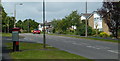
Leabrook Road, Dronfield Woodhouse
Looking past the postbox near the turn for Mapperley Road.
Image: © Andrew Hill
Taken: 24 May 2011
0.05 miles
2
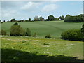
Footpath to Dronfield Woodhouse from Cowley
The footpath crosses fields and a little valley west of Kitchen Wood.
Image: © Andrew Hill
Taken: 24 May 2011
0.15 miles
3
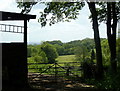
By the edge of Kitchen Wood
A glimpse between a barn and trees at the edge of the wood
Image: © Andrew Hill
Taken: 24 May 2011
0.17 miles
5
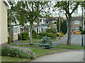
Houses near the edge of Dronfield Woodhouse
Where Kitchen Wood Lane meets Ashford Road.
Image: © Andrew Hill
Taken: 24 May 2011
0.21 miles
6
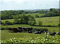
Cattle and meadow land towards Cowley
Looking due south from the track to Kitchen Wood.
Image: © Andrew Hill
Taken: 24 May 2011
0.21 miles
7
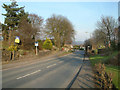
Carr Lane.
The B6056 road heading towards Gosforth Valley.
Image: © Mike Fowkes
Taken: 23 Mar 2006
0.24 miles
8
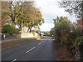
Carr Lane in Dronfield Woodhouse
The B6056 road pictured here on a bright and autumnal midweek afternoon.
Image: © Jonathan Clitheroe
Taken: 7 Nov 2012
0.25 miles