IMAGES TAKEN NEAR TO
S18 6QZ
Introduction
This page details the photographs taken nearby to S18 6QZ by members of the Geograph project.
The Geograph project started in 2005 with the aim of publishing, organising and preserving representative images for every square kilometre of Great Britain, Ireland and the Isle of Man.

There are currently over 7.5m images from over14,400 individuals and you can help contribute to the project by visiting https://www.geograph.org.uk
Image Map
Images are licensed for reuse under creativecommons.org/licenses/by-sa/2.0
Notes
- Clicking on the map will re-center to the selected point.
- The higher the marker number, the further away the image location is from the centre of the postcode.
Image Listing (23 Images Found)
Images are licensed for reuse under creativecommons.org/licenses/by-sa/2.0
Image
Details
Distance
1
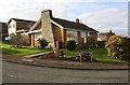
A bungalow at Cavendish Rise / Curzon Avenue junction
Image: © Roger Templeman
Taken: 11 Feb 2019
0.04 miles
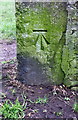
2
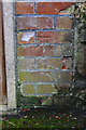
Benchmark on Gosforth Lane electricity substation
Ordnance Survey cut mark benchmark levelled at 186.580m above Newlyn Datum
Image: © Roger Templeman
Taken: 11 Feb 2019
0.05 miles
3
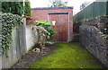
Gosforth Lane electricity substation
There is an OS benchmark Image in the bricks on the right hand side of the substation doors.
Image: © Roger Templeman
Taken: 11 Feb 2019
0.05 miles
4
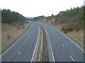
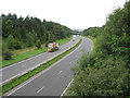
Dronfield bypass.
A view looking north along the A61 Dronfield bypass.
Image: © Mike Fowkes
Taken: 17 Feb 2006
0.06 miles
5

Dronfield : The A61 Unstone-Dronfield By-Pass
A road heading into and through Dronfield.
Image: © Lewis Clarke
Taken: 30 Sep 2018
0.07 miles
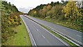
6

North East Derbyshire : The A61 Unstone Dronfield By-Pass
A road between Chesterfield and Dronfield.
Image: © Lewis Clarke
Taken: 1 Oct 2018
0.08 miles
7
Gosforth Lane view north of (A61) Unstone / Dronfield Bypass
Image: © Alan Heardman
Taken: 18 Aug 2009
0.09 miles
8
Benchmark on gatepost at entrance to recreation ground from Gosforth Lane
Ordnance Survey cut mark benchmark levelled at 197.700m above Newlyn Datum
Image: © Roger Templeman
Taken: 11 Feb 2019
0.11 miles
9
A61 Dronfield by-pass
It's rarely as clear of traffic when I drive this stretch!
Image: © Chris Morgan
Taken: 18 Nov 2013
0.12 miles
10
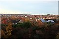
Dronfield roofscape
Taken from a footbridge over the A61 Dronfield by-pass. At dusk this was the first blue sky we had seen all day. On the skyline are the Norton water tower Image and the Herdings multi-storey flats in Sheffield.
Image: © Graham Hogg
Taken: 18 Nov 2013
0.12 miles