IMAGES TAKEN NEAR TO
Twentywell Lane, SHEFFIELD, S17 4QE
Introduction
This page details the photographs taken nearby to Twentywell Lane, S17 4QE by members of the Geograph project.
The Geograph project started in 2005 with the aim of publishing, organising and preserving representative images for every square kilometre of Great Britain, Ireland and the Isle of Man.

There are currently over 7.5m images from over14,400 individuals and you can help contribute to the project by visiting https://www.geograph.org.uk
Image Map
Images are licensed for reuse under creativecommons.org/licenses/by-sa/2.0
Notes
- Clicking on the map will re-center to the selected point.
- The higher the marker number, the further away the image location is from the centre of the postcode.
Image Listing (123 Images Found)
Images are licensed for reuse under creativecommons.org/licenses/by-sa/2.0
Image
Details
Distance
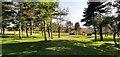
2
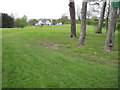
Abbeydale Golf Course towards the Club House
Image: © Chris Wimbush
Taken: 13 May 2010
0.07 miles
4
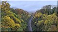
Twentywell Sick Cutting, towards Dore South Junction
Taken from above north portal of Bradway Tunnel where the Midland Mainline from the south emerges into Sheffield and South Yorkshire
Image: © Chris Morgan
Taken: 12 Nov 2021
0.09 miles
5
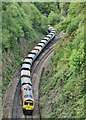
Class 66 66623 crosses Dore South Junction and heads into Bradway Tunnel
With 13.41 ID 639H from Tunstead Sidings to Brentford Town Days Freightliner Heavy Haul. The tail of the train is just exiting short Dore Tunnel that connects the Hope Valley and Midland Mainlines.
Loaded with limestone aggregate from the quarries near Buxton there's less of the Peak District left after every load.
Image: © Chris Morgan
Taken: 12 May 2022
0.10 miles
6
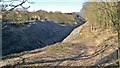
Cutting by Twentywell Lane at north entrance to Bradway Tunnel
Twentywell Lane now runs to the right of this picture. Originally, before the railway cutting was dug up to Bradway Tunnel, it followed the line shown here. The course of the old road was revealed after all vegetation was removed from the rocky sides to reduce the risk to trains running below. The sides of the cutting are now covered by a strong wire mesh netting.
Image: © Chris Morgan
Taken: 2 Mar 2013
0.10 miles
7
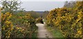
Gorse takes over
This area is known as the railway triangle, consisting of spoil from Bradway Tunnel and Twentywell Sick cutting deposited in the late 1860s before the mainline was opened in 1870.
Image: © Chris Morgan
Taken: 9 Apr 2020
0.10 miles
8
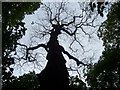
Death of a monster
A dead oak tree creates a break in the canopy in Ladies Spring Wood.
Image: © Martin Speck
Taken: 11 May 2009
0.10 miles
9

Red sky in the morning, shepherds warning
At 6.21. By 9.00 it was raining!
Image: © Chris Morgan
Taken: 7 Sep 2020
0.11 miles