IMAGES TAKEN NEAR TO
Chatsworth Road, SHEFFIELD, S17 3QG
Introduction
This page details the photographs taken nearby to Chatsworth Road, S17 3QG by members of the Geograph project.
The Geograph project started in 2005 with the aim of publishing, organising and preserving representative images for every square kilometre of Great Britain, Ireland and the Isle of Man.

There are currently over 7.5m images from over14,400 individuals and you can help contribute to the project by visiting https://www.geograph.org.uk
Image Map
Images are licensed for reuse under creativecommons.org/licenses/by-sa/2.0
Notes
- Clicking on the map will re-center to the selected point.
- The higher the marker number, the further away the image location is from the centre of the postcode.
Image Listing (49 Images Found)
Images are licensed for reuse under creativecommons.org/licenses/by-sa/2.0
Image
Details
Distance
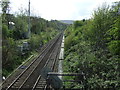
1
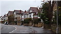
King Ecgbert Road
The residential street leads up towards King Ecgbert secondary school.
Image: © Andrew Hill
Taken: 20 Nov 2012
0.07 miles
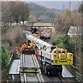
2
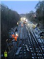
Working all hours
Relaying tracks at Totley as part of the Hope Valley Capacity Scheme improvements
Image: © Chris Morgan
Taken: 21 Jan 2023
0.08 miles
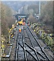
3
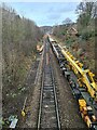
Laying new junction at Dore West
Part of the Hope Valley Capacity Scheme due to be completed over the next 12-15 months.
The junction seen on the right was disconnected below the train last year and is out of service. The new junction will face the opposite way and probably won't be connected for signalling and operational purposes before the late autumn, if all goes to plan.
Image: © Chris Morgan
Taken: 14 Jan 2023
0.08 miles
4
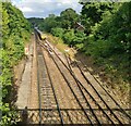
Site of former siding by Totley Brook Road
The siding has been disconnected for some time but local folk lore suggests Queen Elizabeth may have stayed there for a night in the Royal Train early in her reign. (Maybe the train stayed while she popped over to stay with the Duke of Devonshire at Chatsworth?)
The crossover has just been disconnected and will shortly be replaced by one in the opposite direction as part of the current Hope Valley route improvements.
Curiously the road parallel to the railway on the left is called Totley Brook Road. The Totley Brook is not here, but the Old Hay Brook runs parallel to the right, behind the trees and houses. Totley Brook and the Old Hay Brook meet just beyond the distant road bridge to form the River Sheaf.
A train of empty wagons is returning towards the limestone quarries near Buxton.
Image: © Chris Morgan
Taken: 31 Aug 2022
0.09 miles
6
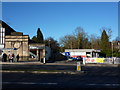
Hair Salon and Tesco Express
On Baslow Road, Abbeydale Park; an example of neighbouring buildings both quite different from their previous use. Tesco used to be a petrol station and the Hair Bar was once a library. The Library at Totley is now Image
Image: © Peter Barr
Taken: 30 Jan 2010
0.10 miles
7
New Dore West Junction being installed
View from other side of the road bridge see; https://www.geograph.org.uk/photo/7383124
Image: © Chris Morgan
Taken: 15 Jan 2023
0.10 miles
8
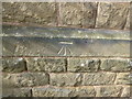
Cut Mark 22 King Ecgbert Rd Sheffield
as above
Image: © Monica Stagg
Taken: 1 Mar 2015
0.10 miles
9
Track laying by numbers
New Dore West Junction has just been installed, now to reconnect the rest of the track. For view from other side of the road bridge see; https://www.geograph.org.uk/photo/7383128
Image: © Chris Morgan
Taken: 15 Jan 2023
0.11 miles
10
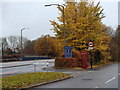
Totley Brook Road by the A621
Totley Brook Road starts parallel with the main road before curving right to follow the edge of the railway line.
Image: © Andrew Hill
Taken: 20 Nov 2012
0.12 miles