IMAGES TAKEN NEAR TO
Wessex Gardens, SHEFFIELD, S17 3PQ
Introduction
This page details the photographs taken nearby to Wessex Gardens, S17 3PQ by members of the Geograph project.
The Geograph project started in 2005 with the aim of publishing, organising and preserving representative images for every square kilometre of Great Britain, Ireland and the Isle of Man.

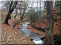
There are currently over 7.5m images from over14,400 individuals and you can help contribute to the project by visiting https://www.geograph.org.uk
Image Map
Images are licensed for reuse under creativecommons.org/licenses/by-sa/2.0
Notes
- Clicking on the map will re-center to the selected point.
- The higher the marker number, the further away the image location is from the centre of the postcode.
Image Listing (15 Images Found)
Images are licensed for reuse under creativecommons.org/licenses/by-sa/2.0
Image
Details
Distance
1
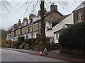
Houses on Totley Brook Road
A terrace of houses on the residential street.
Image: © Andrew Hill
Taken: 20 Nov 2012
0.07 miles
2
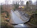
Aqueduct on the Oldhay Brook
The Oldhay Brook at Totley Brook crossing the Midland Railway cutting in an aqueduct.
Image: © Martin Speck
Taken: 28 Mar 2009
0.10 miles
3
Aqueduct, Oldhay Brook
The aqueduct carries the stream over the railway line a short distance below the eastern end of the Totley tunnel. A series of weirs takes the stream down the valley.
Image: © Andrew Hill
Taken: 20 Nov 2012
0.12 miles
4
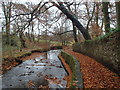
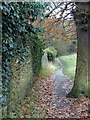
Path by Oldhay Brook
Autumn leaves cover the path by the stream.
Image: © Andrew Hill
Taken: 20 Nov 2012
0.12 miles
5
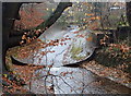
Oldhay Brook
Looking upstream by some of the line of weirs along this stretch of the stream. Around the curve the start of the aqueduct over the railway can be seen.
Image: © Andrew Hill
Taken: 20 Nov 2012
0.15 miles
6
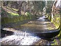
Oldhay Brook stepped weirs
The Oldhay Brook at Totley Brook descends a flight of steps from the aqueduct over the railway-line upstream. See Image
Image: © Martin Speck
Taken: 28 Mar 2009
0.15 miles
7
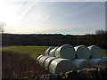
Fields between Totley and Dore, Sheffield
From the top of Hillfoot Road
Image: © Peter Barr
Taken: 1 Feb 2010
0.17 miles
8
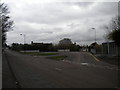
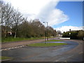
Bus turning circle, Totley Brook (1)
The large turning circle on Totley Brook Road, configured to allow buses to arrive from and depart in either direction, contains three bus stops: the one on the right is the nominal terminus of First Sheffield route 98 to Ecclesfield via Sheffield city centre, while the other two are used by school services to King Ecgbert School (out of frame to the right).
Image: © Richard Vince
Taken: 27 Apr 2013
0.17 miles
9
Bus turning circle, Totley Brook (2)
The large turning circle on Totley Brook Road, configured to allow buses to arrive from and depart in either direction, is the nominal terminus of First Sheffield route 98 to Ecclesfield via Sheffield city centre (which does not turn here as it does a unidirectional loop of the area). It is also used by school services to King Ecgbert School (out of frame to the right), hence its size.
Image: © Richard Vince
Taken: 27 Apr 2013
0.17 miles
10
Footpath to Hillfoot Road
The path crosses the edge of a field by a wall towards the lane from a footbridge over Oldhay Brook.
Image: © Andrew Hill
Taken: 20 Nov 2012
0.21 miles