IMAGES TAKEN NEAR TO
Vicarage Lane, SHEFFIELD, S17 3GY
Introduction
This page details the photographs taken nearby to Vicarage Lane, S17 3GY by members of the Geograph project.
The Geograph project started in 2005 with the aim of publishing, organising and preserving representative images for every square kilometre of Great Britain, Ireland and the Isle of Man.

There are currently over 7.5m images from over14,400 individuals and you can help contribute to the project by visiting https://www.geograph.org.uk
Image Map (Loading...)


Getting Data...Please wait
Leaflet Map data © OpenStreetMap
Images are licensed for reuse under creativecommons.org/licenses/by-sa/2.0
Notes
- Clicking on the map will re-center to the selected point.
- The higher the marker number, the further away the image location is from the centre of the postcode.
Image Listing (67 Images Found)
Images are licensed for reuse under creativecommons.org/licenses/by-sa/2.0
Image
Details
Distance
1
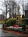
War memorial
Effective use of a small space at the corner of Vicarage Lane and Savage Lane.
Image: © Andrew Hill
Taken: 20 Nov 2012
0.02 miles
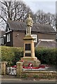

6

War Memorial and Village Green in Dore
The stone on the green ahead recalls a Dark Ages battle.
Image: © Jonathan Clitheroe
Taken: 18 Jul 2014
0.04 miles
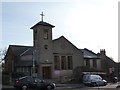
7
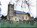
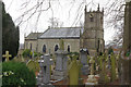
Christ church, Dore.
The village church in Dore which was built in 1828.
Image: © Mike Fowkes
Taken: 20 Jan 2006
0.04 miles
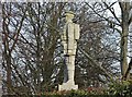
8

Commemorative monolith in Dore Village
The Dore Village Society's website has this to say:
"The importance of Dore was its position on the boundary of the Anglo Saxon kingdoms of Mercia, recently conquered by King Ecgbert of Wessex, and Northumbria, the second most powerful kingdom. At the time, Northumbria was under pressure from viking raids and unable to fight on two fronts, leading to the acceptance of Ecgbert as overlord and effectively the first king of all England. The event is commemorated on the village green by a gritstone monolith with a black granite plaque in the shape of a Saxon shield, appropriately emblazoned by a Wyvern, the war emblem of Wessex."
For the wording on the plaque see Image
Image: © Graham Hogg
Taken: 25 Oct 2020
0.04 miles
9
Christ Church, Dore
There has been a chapel in Dore since the late 1100s. It was a chapel of ease within the Dronfield parish until 1844. The present church was built in 1829 and was then in the diocese of Lichfield and Coventry and the See of Canterbury. It's now in the diocese of Sheffield and the See of York.
Image: © Chris Morgan
Taken: 9 Apr 2020
0.04 miles
10
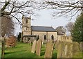
Dore Church
There are some substantial headstones here perhaps indicative of the fact that Dore has long been an affluent area. Elsewhere in the churchyard smaller stones mark the graves of railway navvies and their families who died of smallpox while digging Totley Tunnel. Christ Church itself dates from 1828 and was designed by Richard Furniss (or Furness) a local schoolmaster, initially as a chapel of ease to Dronfield. Dore became a parish in its own right in 1844.
Image: © Stephen McKay
Taken: 14 Mar 2018
0.05 miles