IMAGES TAKEN NEAR TO
Church Lane, SHEFFIELD, S17 3GT
Introduction
This page details the photographs taken nearby to Church Lane, S17 3GT by members of the Geograph project.
The Geograph project started in 2005 with the aim of publishing, organising and preserving representative images for every square kilometre of Great Britain, Ireland and the Isle of Man.

There are currently over 7.5m images from over14,400 individuals and you can help contribute to the project by visiting https://www.geograph.org.uk
Image Map
Images are licensed for reuse under creativecommons.org/licenses/by-sa/2.0
Notes
- Clicking on the map will re-center to the selected point.
- The higher the marker number, the further away the image location is from the centre of the postcode.
Image Listing (50 Images Found)
Images are licensed for reuse under creativecommons.org/licenses/by-sa/2.0
Image
Details
Distance
1
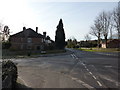
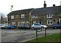
On Church Lane, Dore
At junction of Drury Lane and Furniss Avenue
Image: © Peter Barr
Taken: 1 Feb 2010
0.02 miles
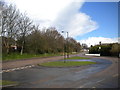
2
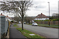
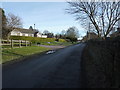
Furniss Avenue, Dore
Looking down Furniss Avenue from its junction with Church Lane to the south of Dore village. The road is recorded as having been officially opened in 1929 and the houses, mostly substantial semis, appear to date from the 1930s. The name probably commemorates Richard Furness, a 19th century local schoolmaster.
Image: © Stephen McKay
Taken: 14 Mar 2018
0.06 miles
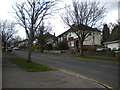
3
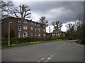
Church Lane, Dore
The trees that line Church Lane south of Dore village centre are regrowing following some apparently severe pruning. This view was taken from the junction with Furniss Avenue (right foreground).
Image: © Richard Vince
Taken: 27 Apr 2013
0.08 miles
4
Church Lane
Heading south west towards Totley.
Image: © JThomas
Taken: 26 Apr 2014
0.09 miles
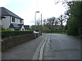
5
On Old Hay Lane, Dore
Approaching Old Hay Gardens
Image: © Peter Barr
Taken: 1 Feb 2010
0.10 miles
7
Furniss Avenue, Totley Brook
A view from the end of Totley Brook Road, as Furniss Avenue climbs towards Church Lane at the south end of Dore.
Image: © Richard Vince
Taken: 27 Apr 2013
0.13 miles
8
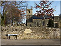
Christ Church, in the Parish of Dore
The plaque in the wall reads "Cat Croft Green; the area opposite was one of the six greens of Dore, also known as Catty Croft Green or Caddy Green"
Image: © Peter Barr
Taken: 1 Feb 2010
0.13 miles
9
Hare & Hounds at Dore, Nr Sheffield
Image: © Andrew Loughran
Taken: 19 Feb 2006
0.13 miles
10
Bus turning circle, Totley Brook (2)
The large turning circle on Totley Brook Road, configured to allow buses to arrive from and depart in either direction, is the nominal terminus of First Sheffield route 98 to Ecclesfield via Sheffield city centre (which does not turn here as it does a unidirectional loop of the area). It is also used by school services to King Ecgbert School (out of frame to the right), hence its size.
Image: © Richard Vince
Taken: 27 Apr 2013
0.14 miles