IMAGES TAKEN NEAR TO
Westbrook Bank, SHEFFIELD, S11 8YJ
Introduction
This page details the photographs taken nearby to Westbrook Bank, S11 8YJ by members of the Geograph project.
The Geograph project started in 2005 with the aim of publishing, organising and preserving representative images for every square kilometre of Great Britain, Ireland and the Isle of Man.

There are currently over 7.5m images from over14,400 individuals and you can help contribute to the project by visiting https://www.geograph.org.uk
Image Map
Images are licensed for reuse under creativecommons.org/licenses/by-sa/2.0
Notes
- Clicking on the map will re-center to the selected point.
- The higher the marker number, the further away the image location is from the centre of the postcode.
Image Listing (103 Images Found)
Images are licensed for reuse under creativecommons.org/licenses/by-sa/2.0
Image
Details
Distance
2
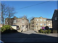
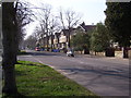
Typical Edwardian villa on Psalter Lane, Sheffield
Image: © Neil Theasby
Taken: 29 Nov 2012
0.04 miles
3
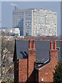
The Royal Hallamshire Hospital
Seen from Bagshot Road, Sharrowvale
Image: © Neil Theasby
Taken: 27 Mar 2020
0.04 miles
4
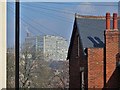
View from Bagshot Road, Sheffield
To The Royal Hallamshire Hospital
Image: © Neil Theasby
Taken: 27 Mar 2020
0.05 miles
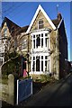
6
Psalter Lane
Psalter Lane near to the junction of Cherry Tree Road. This is a similar view to the Frith Collection image S108064. http://www.francisfrith.com/sheffield/photos/psalter-lane-c1955_s108064/
Image: © Martin Speck
Taken: 15 Mar 2012
0.08 miles
7
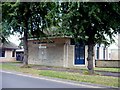
Salvation Army Citadel, Nether Edge, Sheffield
Image: © Graham Hogg
Taken: 9 Aug 2010
0.08 miles
8
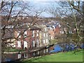
Sharrow mill and millpond
Many of the 'wheels' on Sheffield's rivers and streams were used to grind knives. Some were used to power tilt-hammers to beat metal. At least one was used to grind corn. The mill at Sharrow was used to grind snuff.
Image: © Martin Speck
Taken: 6 Mar 2009
0.09 miles
10
Wilson's Snuff Mill
Wilkson's Snuff Mill from the end of Frog Walk, Sharrow Vale Road
Image: © Julian Baker
Taken: 24 Oct 2014
0.09 miles