IMAGES TAKEN NEAR TO
Ecclesall Road, SHEFFIELD, S11 8HY
Introduction
This page details the photographs taken nearby to Ecclesall Road, S11 8HY by members of the Geograph project.
The Geograph project started in 2005 with the aim of publishing, organising and preserving representative images for every square kilometre of Great Britain, Ireland and the Isle of Man.

There are currently over 7.5m images from over14,400 individuals and you can help contribute to the project by visiting https://www.geograph.org.uk
Image Map (Loading...)


Getting Data...Please wait
Leaflet Map data © OpenStreetMap
Images are licensed for reuse under creativecommons.org/licenses/by-sa/2.0
Notes
- Clicking on the map will re-center to the selected point.
- The higher the marker number, the further away the image location is from the centre of the postcode.
Image Listing (158 Images Found)
Images are licensed for reuse under creativecommons.org/licenses/by-sa/2.0
Image
Details
Distance
1

Yellow bikes promoting 'Le Grand D?part': Waitrose car park
The 2014 Tour de France is starting in Yorkshire and on day 2 will end in Sheffield. To promote the event 40 reclaimed bikes have been painted yellow and placed at various locations on the route and around the city. This one is in a supermarket car park off Ecclesall Road
Image: © Graham Hogg
Taken: 26 Jun 2014
0.04 miles

3
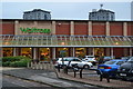
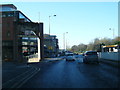
Supermarket and Car Park
The "Waitrose" supermarket close to the Moore Street roundabout on Sheffield's inner ring road.
Image: © Neil Theasby
Taken: 10 Oct 2010
0.06 miles
5
William Street
This was once the site of the Jolly Buffer public house. It has since been developed into high density housing with a chip shop below.
Image: © Martin Speck
Taken: 18 Oct 2007
0.07 miles
6
Supermarket on Sheffield ring road, with residential towers beyond
Not a late evening view, but shortly before a heavy rainstorm.
Image: © David Martin
Taken: 27 Aug 2016
0.07 miles
7

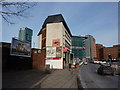
Wards Brewery Gateway
A forlorn reminder of what used to be
Image: © Glyn Baker
Taken: 16 Apr 2011
0.07 miles
8
A625 at the commemorative arch to Wards Brewery
Image: © Colin Pyle
Taken: 13 Dec 2014
0.08 miles
9
Chinese fireworks emporium
A view at the bottom of London Road, Sheffield, by the junction with St Mary's Gate; several new blocks recently built include flats, offices (still mainly empty) and hotel. The horizontally striped building on the right is BIS ( Dept for Business, Innovation and Skills) which will no doubt have a new title next year
Image: © Peter Barr
Taken: 1 Feb 2010
0.08 miles
10
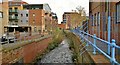
Porter Brook
The Porter Brook flows largely unseen behind high buildings and often beneath them in culverts. To the left used to be Wards Brewery, the site now redeveloped as flats.
Image: © Chris Morgan
Taken: 24 Nov 2012
0.08 miles