IMAGES TAKEN NEAR TO
Sheephill Road, SHEFFIELD, S11 7TU
Introduction
This page details the photographs taken nearby to Sheephill Road, S11 7TU by members of the Geograph project.
The Geograph project started in 2005 with the aim of publishing, organising and preserving representative images for every square kilometre of Great Britain, Ireland and the Isle of Man.

There are currently over 7.5m images from over14,400 individuals and you can help contribute to the project by visiting https://www.geograph.org.uk
Image Map
Images are licensed for reuse under creativecommons.org/licenses/by-sa/2.0
Notes
- Clicking on the map will re-center to the selected point.
- The higher the marker number, the further away the image location is from the centre of the postcode.
Image Listing (63 Images Found)
Images are licensed for reuse under creativecommons.org/licenses/by-sa/2.0
Image
Details
Distance
1
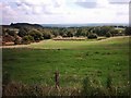
Limb Valley and Copperas House.
A popular spot, Copperas House is a ruin in the trees in the middle of the picture.
Image: © nj
Taken: 16 Sep 2005
0.04 miles
2
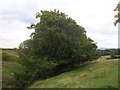
Limb Brook or Fenny Brook
Limb Brook where it passes through Barber Fields. Sidney Addy, in his 1888 book on the Sheffield dialect states that, "A stream called, on the ordnance survey map, Fenny Brook," flowed here. The modern OS map now shows this as Limb Brook. Although this area is now farmland there is historical evidence that a shallow coal drift-mine served by a short railway once existed in these fields. All that remains of this industry is a spoil-tip on the North bank of the brook.
Image: © Martin Speck
Taken: 13 Aug 2009
0.05 miles
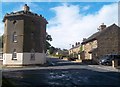
3
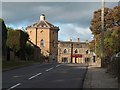
Round Tower and Norfolk Arms at Ringinglow
Image: © Neil Theasby
Taken: 11 Oct 2009
0.06 miles
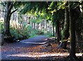
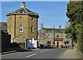
5
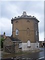
The Roundhouse, Ringinglow
The Roundhouse, a toll house at the end of the Houndkirk turnpike road. Some older maps show this section of the road as Houndkirk Road, but the modern street sign on the building shows it as Sheephill Road.
Image: © Martin Speck
Taken: 19 Jun 2009
0.07 miles
6
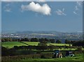
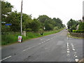
Countryside south of Ringinglow
Looking over Sheephill Road towards Dore and Totley
Image: © Neil Theasby
Taken: 17 Oct 2016
0.09 miles
7
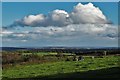
Clouds over south west Sheffield
View from Houndkirk Road car park just south of Ringinglow
Image: © Neil Theasby
Taken: 17 Oct 2016
0.09 miles
8
Cottages and Toll House in Ringinglow
The name of this small village is probably derived from the site of a round barrow which existed in the area.
Image: © Jonathan Clitheroe
Taken: 14 Sep 2012
0.10 miles
10
At Ringinglow
Showing The Round House and "The Norfolk Arms". I took a similar picture in October 2009 https://www.geograph.org.uk/photo/1661493
Image: © Neil Theasby
Taken: 29 Sep 2018
0.11 miles