IMAGES TAKEN NEAR TO
Wilkinson Street, SHEFFIELD, S10 2GA
Introduction
This page details the photographs taken nearby to Wilkinson Street, S10 2GA by members of the Geograph project.
The Geograph project started in 2005 with the aim of publishing, organising and preserving representative images for every square kilometre of Great Britain, Ireland and the Isle of Man.

There are currently over 7.5m images from over14,400 individuals and you can help contribute to the project by visiting https://www.geograph.org.uk
Image Map
Images are licensed for reuse under creativecommons.org/licenses/by-sa/2.0
Notes
- Clicking on the map will re-center to the selected point.
- The higher the marker number, the further away the image location is from the centre of the postcode.
Image Listing (734 Images Found)
Images are licensed for reuse under creativecommons.org/licenses/by-sa/2.0
Image
Details
Distance
1
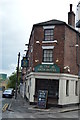
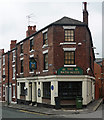
The Bath Hotel
Grade II listed. http://www.britishlistedbuildings.co.uk/en-475750-bath-hotel-
The pub is on CAMRAs inventory of historic interiors.
Image: © N Chadwick
Taken: 28 Aug 2015
0.04 miles
2
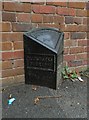
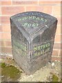
Old Boundary Marker by Gell Street, Sheffield
Parish Boundary Marker by the UC road, in parish of Sheffield (Sheffield District), on the west side of Gell Street near its junction with Conway Street, in the pavement, back to the front garden brick wall of number 94. ECCLESALL / BIERLOW and NETHER / HALLAM on adjacent faces in raised lettering. Both of these were townships in Sheffield parish until 1866, then separate parishes until 1904 when they combined with Heeley, Upper Hallam and Norton Within to create Ecclesall parish.
Surveyed
Milestone Society National ID: YW_ECCNHA01pb
Image: © Alan Rosevear
Taken: 23 Sep 2012
0.04 miles
3
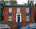
94 Gell Street, Sheffield
Early C19th brick house with a Doric doorcase and painted wedge-lintels to the windows. Grade II listed.
Image: © Stephen Richards
Taken: 11 Jun 2012
0.04 miles
4
94, Gell St
Grade II listed. http://www.britishlistedbuildings.co.uk/en-458224-94-gell-street-
Image: © N Chadwick
Taken: 28 Aug 2015
0.04 miles
5
Old Boundary Marker on Convent Walk, Sheffield
Parish Boundary Marker against a house wall on the south side of Convent Walk, at this point an alleyway between Gell Street and Victoria Street, Sheffield. SHEFFIELD / TOWNSHIP and NETHER / HALLAM in raised lettering on adjacent faces. Nether Hallam was a township in Sheffield parish until 1866, then a separate parish until 1904 when it became part of Ecclesall parish.
Milestone Society National ID: YW_SHF08pb
Image: © C Minto
Taken: 16 May 2022
0.04 miles
6
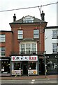
257 Glossop Road, Sheffield
Originally this would have matched its neighbours which date from c.1820, but was substantially rebuilt c.1900 to a rather quirky design. The group of three buildings is Listed Grade II.
Image: © Alan Murray-Rust
Taken: 25 Aug 2023
0.04 miles
7
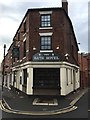
The Bath Hotel
This small pub on Victoria Street takes its name from the nearby Glossop Road Baths.
Image: © Graham Hogg
Taken: 14 Nov 2018
0.04 miles
8
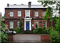
22 Wilkinson Street, Sheffield
Early Victorian villa, dated c1840, with a Greek Doric doorcase. Grade II listed.
Currently occupied by Action Housing and Support, "a registered charity ... working to enable vulnerable people to establish a home and live responsibility in society".
Image: © Stephen Richards
Taken: 15 Jun 2012
0.05 miles
9
The Bath Hotel
The Bath Hotel, Sheffield won the CAMRA/English Heritage 2003 Pub Design Award for conservation.
Image: © Dave Pickersgill
Taken: 3 Apr 2013
0.05 miles
10
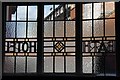
Bath Hotel, Victoria Street, Sheffield
Attractive brick pub, originally a shop when built c1876. It has decorative leaded windows (Image]), dating from a refurbishment in 1931, and decorative lintels. Grade II listed.
Image: © Stephen Richards
Taken: 11 Jun 2012
0.05 miles