IMAGES TAKEN NEAR TO
New Road, RM9 6PH
Introduction
This page details the photographs taken nearby to New Road, RM9 6PH by members of the Geograph project.
The Geograph project started in 2005 with the aim of publishing, organising and preserving representative images for every square kilometre of Great Britain, Ireland and the Isle of Man.

There are currently over 7.5m images from over14,400 individuals and you can help contribute to the project by visiting https://www.geograph.org.uk
Image Map
Images are licensed for reuse under creativecommons.org/licenses/by-sa/2.0
Notes
- Clicking on the map will re-center to the selected point.
- The higher the marker number, the further away the image location is from the centre of the postcode.
Image Listing (64 Images Found)
Images are licensed for reuse under creativecommons.org/licenses/by-sa/2.0
Image
Details
Distance
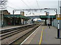
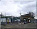
1
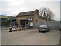
Dagenham Dock railway station, Greater London
Opened in 1908 by the London Tilbury & Southend Railway on what is now the Tilbury loop. Forecourt.
Image: © Nigel Thompson
Taken: 24 Feb 2012
0.03 miles
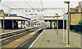
3
Dagenham Dock railway station, Greater London
Opened in 1908 by the London Tilbury & Southend Railway on what is now the Tilbury loop.
View west towards Barking and London Fenchurch Street.
Image: © Nigel Thompson
Taken: 24 Feb 2012
0.03 miles
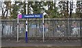
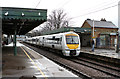
4
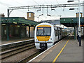
c2c train to Fenchurch Street arrives at Dagenham Dock
Unit 357 041.
Image: © Robin Webster
Taken: 2 Apr 2011
0.04 miles
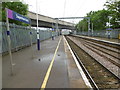
5
Dagenham Dock station
Looking towards Tilbury. Decorative fringed valances survive here on the canopies, although the green colour scheme is rather drab. It is served by two c2c trains an hour in each direction off peak.
Image: © Robin Webster
Taken: 2 Apr 2011
0.04 miles
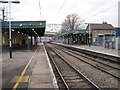
6
Dagenham Dock station
View eastward, towards Tilbury, Southend-on-Sea and Shoeburyness: ex-Midland (London, Tilbury & Southend) Tilbury Loop line. This was before the HS1 line to St Pancras was built beside it - cf. Image
Image: © Ben Brooksbank
Taken: 25 May 1991
0.04 miles
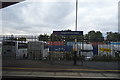
8
Dagenham Dock station
The construction of the London, Tilbury & Southend Railway line was authorised by Parliament on 17th June 1852. The first section was opened between Forest Gate junction on the Eastern Counties Railway and Tilbury, via Barking and Grays on 13th April 1854. The London, Tilbury & Southend Railway direct line from Bow to Barking (avoiding Stratford and Forest Gate) was constructed from west to east in 1858. Dagenham Dock station did not open at this time but came later when it was opened on 1st July 1908, primarily to serve the industrial areas, including the Ford Assembly Plant.
The Channel Tunnel Rail Link passes immediately to the south of the station, having emerged from the tunnel from Stratford just west of here. The first Eurostars ran along the line on 6th November 2007 following the completion of High Speed 1 and the opening of St Pancras International. Southeastern Javelins now also use the line.
In this photograph the A13 passes overhead while the next station in this direction is Barking. HS1 is just out of sight to the left of the railings.
Image: © Marathon
Taken: 1 Jun 2016
0.04 miles
9
Dagenham Dock Station
C2C Class 357 (357216) arrives at Dagenham Dock station with a service for Grays. The station, which opened in 1908, is served half-hourly from Fenchurch Street on Monday to Saturday - the service is hourly on Sundays.
Image: © Martin Addison
Taken: 12 Apr 2013
0.04 miles
10
Dagenham Dock Railway Station
As seen from the end of Chequers Lane.
In the background is the A13 dual carriageway roadbridge, heading right towards Barking.
Image: © David Anstiss
Taken: 31 Mar 2013
0.04 miles