IMAGES TAKEN NEAR TO
Surmans Close, DAGENHAM, RM9 4XE
Introduction
This page details the photographs taken nearby to Surmans Close, RM9 4XE by members of the Geograph project.
The Geograph project started in 2005 with the aim of publishing, organising and preserving representative images for every square kilometre of Great Britain, Ireland and the Isle of Man.

There are currently over 7.5m images from over14,400 individuals and you can help contribute to the project by visiting https://www.geograph.org.uk
Image Map
Images are licensed for reuse under creativecommons.org/licenses/by-sa/2.0
Notes
- Clicking on the map will re-center to the selected point.
- The higher the marker number, the further away the image location is from the centre of the postcode.
Image Listing (25 Images Found)
Images are licensed for reuse under creativecommons.org/licenses/by-sa/2.0
Image
Details
Distance
1
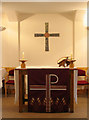
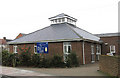
St John the Divine, Goresbrook Road, Dagenham - East end
Image: © John Salmon
Taken: 9 Mar 2005
0.00 miles
2
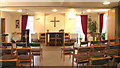
St John the Divine, Goresbrook Road, Dagenham - Altar
Image: © John Salmon
Taken: 9 Mar 2005
0.01 miles
3
St John the Divine, Goresbrook Road, Dagenham
Image: © John Salmon
Taken: 9 Mar 2005
0.01 miles
4
St John the Devine Church Dagenham Essex
Image: © Peter Stack
Taken: 25 May 2009
0.01 miles
5
St John the Divine, Goresbrook Road, Dagenham
Image: © John Salmon
Taken: 9 Mar 2005
0.01 miles
6
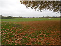
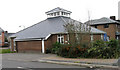
Castle Green
The name dates back over 200 years to a time when the area was rural. The "castle" that gave its name to the place was a castellated house which was built around 1800 and survived until 1938.
When the Becontree Estate was built in the 1920s and early 1930s, a strip of open land north of Ripple Road was left as a buffer between housing to the north and land set aside for industry on the former marshland to the south. This is now known as Castle Green.
More information about Castle Green can be found at https://en.wikipedia.org/wiki/Castle_Green,_London
Image: © Marathon
Taken: 9 Nov 2016
0.10 miles
7
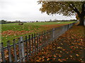
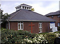
Castle Green
The name dates back over 200 years to a time when the area was rural. The "castle" that gave its name to the place was a castellated house which was built around 1800 and survived until 1938.
When the Becontree Estate was built in the 1920s and early 1930s, a strip of open land north of Ripple Road was left as a buffer between housing to the north and land set aside for industry on the former marshland to the south. This is now known as Castle Green.
More information about Castle Green can be found at https://en.wikipedia.org/wiki/Castle_Green,_London
Image: © Marathon
Taken: 9 Nov 2016
0.10 miles
9
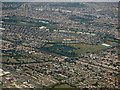
Dagenham from the air
Mayesbrook park and its boating lakes are prominent. Barking and Ilford are in the background.
Image: © Thomas Nugent
Taken: 26 Aug 2019
0.14 miles
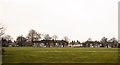
10
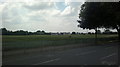
View of the A13 across Goresbrook Sports Ground from Goresbrook Road
Looking south-southwest.
Image: © Robert Lamb
Taken: 23 Jul 2014
0.16 miles