IMAGES TAKEN NEAR TO
Gale Street, DAGENHAM, RM9 4NU
Introduction
This page details the photographs taken nearby to Gale Street, RM9 4NU by members of the Geograph project.
The Geograph project started in 2005 with the aim of publishing, organising and preserving representative images for every square kilometre of Great Britain, Ireland and the Isle of Man.

There are currently over 7.5m images from over14,400 individuals and you can help contribute to the project by visiting https://www.geograph.org.uk
Image Map
Images are licensed for reuse under creativecommons.org/licenses/by-sa/2.0
Notes
- Clicking on the map will re-center to the selected point.
- The higher the marker number, the further away the image location is from the centre of the postcode.
Image Listing (49 Images Found)
Images are licensed for reuse under creativecommons.org/licenses/by-sa/2.0
Image
Details
Distance


4
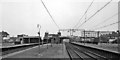
Becontree Station
View eastwards, towards Upminster, Southend-on-Sea and Shoeburyness. Tracks on right are ex-LT&S Fenchurch Street - Upminster - Southend - Shoeburyness line (the wires are up, but electric services did not begin until six months later). On the left are the LT District Line tracks to Upminster.
Image: © Ben Brooksbank
Taken: 12 May 1961
0.06 miles

6

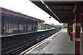
Becontree Underground station, Greater London
Opened in 1926 as Gale Street Halt by the London Midland & Scottish Railway on the line from London to Upminster, this station was renamed and rebuilt in 1932 when the platforms to the left were added. The LMS platforms to the right were closed in 1962. The station transferred from British Rail to London Transport in 1969.
View east towards Dagenham Heathway and Upminster. Like 55% of the London Underground network, this part is actually overground.
Image: © Nigel Thompson
Taken: 24 Sep 2015
0.06 miles
7
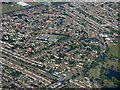
Becontree from the air
Becontree railway station is in the foreground, with Parsloes Park on the right. Roding Primart School https://www.rodingprimaryschool.co.uk/ is prominent in the centre.
Image: © Thomas Nugent
Taken: 26 Aug 2019
0.07 miles