IMAGES TAKEN NEAR TO
Berryman Close, DAGENHAM, RM8 3SS
Introduction
This page details the photographs taken nearby to Berryman Close, RM8 3SS by members of the Geograph project.
The Geograph project started in 2005 with the aim of publishing, organising and preserving representative images for every square kilometre of Great Britain, Ireland and the Isle of Man.

There are currently over 7.5m images from over14,400 individuals and you can help contribute to the project by visiting https://www.geograph.org.uk
Image Map
Images are licensed for reuse under creativecommons.org/licenses/by-sa/2.0
Notes
- Clicking on the map will re-center to the selected point.
- The higher the marker number, the further away the image location is from the centre of the postcode.
Image Listing (22 Images Found)
Images are licensed for reuse under creativecommons.org/licenses/by-sa/2.0
Image
Details
Distance
1
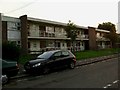
Flats in Seabrooke Rd
Flats of this vintage are not common on the Becontree Estate as it was mostly constructed between the world wars. TQ4786 has just about the least green space of any grid square on the estate it being almost equidistant from Valance Park in the East and Goodmayes park in the West
Image: © Glyn Baker
Taken: 22 Sep 2005
0.14 miles
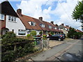
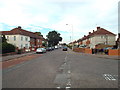
3
Bennett's Castle Lane
One of the more sinuous roads in the Becontree estate, and pre-dating it. Bennett's Castle was just on the left at this end of the lane, and seems to have been a house rather than a castle or an inn.
Image: © Robin Webster
Taken: 24 Apr 2011
0.18 miles

5
Valence Avenue, Becontree
At the junction with Lindisfarne Road
Image: © Geographer
Taken: 4 May 2010
0.21 miles
6
A124 Wood Lane, Becontree
Looking towards the junction with Bennett's Castle Lane near St Elisabeth's Church.
Image: © Geographer
Taken: 4 May 2010
0.22 miles
7
Bennett's Castle Lane, Becontree
Bennett's Castle Lane on the Becontree Estate in east London.
Image: © Malc McDonald
Taken: 28 Aug 2017
0.22 miles
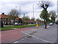
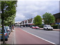
8
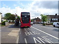
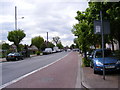
Bus stop and shelter on Longbridge Road, Dagenham
Looking east.
Image: © JThomas
Taken: 11 May 2019
0.22 miles
9
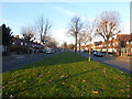
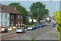
Valence Avenue, Becontree Estate
The London County Council decided to build the Becontree Estate to house many of the people from the East End of London displaced by slum clearance schemes. Barking and Dagenham, being almost flat and well-drained, offered an ideal site. Between 1920 and 1922 the LCC acquired 3,000 acres of land in Barking and Dagenham, as well as adjoining parts of Ilford, using compulsory purchase powers. Building started almost straight away, at first centred near Goodmayes and Chadwell Heath, and from 1923 around Dagenham Village. These centres soon joined up, and building continued until 1934. By 1932 the population had grown to 103,328 from 2,086 in 1922.
Before development took place, most traces of the former landscape were obliterated. All the former farmhouses were demolished with the sole exception of Valence House which was saved when it was purchased from the LCC in 1926 by Dagenham Urban District Council. The landscape was largely devoid of trees and so it is difficult to find any tree within the Becontree Estate which pre-dates the development, other than those in the grounds of Valence House and Parsloes Park.
There was a new layout of geometrically designed roads, sometimes with central reservations as here in Valence Avenue. Some of the pre-existing roads such as Wood Lane and Bennett's Castle Lane were retained, but others such as Gale Street and Broad Street were rerouted or lost.
Image: © Marathon
Taken: 30 Nov 2016
0.23 miles
10
A124 Wood Lane, Becontree
Looking towards Becontree near the junction with Bushgrove Road & Hewitt Road and also near St. Elisabeth's Church
Image: © Geographer
Taken: 4 May 2010
0.23 miles