IMAGES TAKEN NEAR TO
Mildmay Road, ROMFORD, RM7 7DD
Introduction
This page details the photographs taken nearby to Mildmay Road, RM7 7DD by members of the Geograph project.
The Geograph project started in 2005 with the aim of publishing, organising and preserving representative images for every square kilometre of Great Britain, Ireland and the Isle of Man.

There are currently over 7.5m images from over14,400 individuals and you can help contribute to the project by visiting https://www.geograph.org.uk
Image Map
Images are licensed for reuse under creativecommons.org/licenses/by-sa/2.0
Notes
- Clicking on the map will re-center to the selected point.
- The higher the marker number, the further away the image location is from the centre of the postcode.
Image Listing (42 Images Found)
Images are licensed for reuse under creativecommons.org/licenses/by-sa/2.0
Image
Details
Distance
2
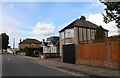
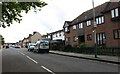
Romford: Mawney Arms
The Mawney Arms is located on Mawney Road at the junction with Willow Street.
Image: © Nigel Cox
Taken: 27 Jul 2008
0.10 miles
4
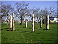
Wooden sculptures in Cottons Park
These sculptured logs were erected in the park in the summer of 2009 to commemorate six local civilians died following enemy bombing during WWII.
Image: © PAUL FARMER
Taken: 17 Apr 2010
0.15 miles
5
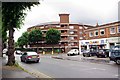
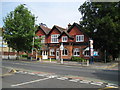
The Rotunda
An unusual block of flats in Romford
Image: © Glyn Baker
Taken: 3 Jul 2012
0.15 miles
7
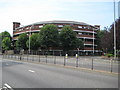
Romford: The Rotunda
Viewing this building on satellite imagery it looks like the old Wembley Stadium, but there is more than a hint that it is not quite symmetrical with the southern end wider than the northern. It is a residential block of flats and is viewed here looking across St Edwards Way, better known as the Romford Ring Road.
Image: © Nigel Cox
Taken: 27 Jul 2008
0.16 miles
8

River Rom in Romford
The River Rom just clips across the north-east corner of this grid square as it goes under the Romford Ring Road, prior to entering a long culvert under the Brewery Development site. This is the view looking downstream from the ring road bridge with a rather attractive footbridge that allows pedestrian access between two car parks.
Image: © Nigel Cox
Taken: 27 Jul 2008
0.17 miles
9

River Rom in Romford
The River Rom just clips across the north-east corner of this grid square as it goes under the Romford Ring Road, prior to entering a long culvert under the Brewery Development site. This is the view looking upstream from the ring road bridge. The grey slab at the top of the photograph is the bottom of a maintenance access ramp.
Image: © Nigel Cox
Taken: 27 Jul 2008
0.17 miles
10
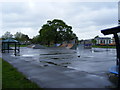
Pathway within Cottons Park Romford
This picture is taken from the London Road entrance to the park
Image: © PAUL FARMER
Taken: 17 Apr 2010
0.18 miles