IMAGES TAKEN NEAR TO
Rom Valley Way, ROMFORD, RM7 0AN
Introduction
This page details the photographs taken nearby to Rom Valley Way, RM7 0AN by members of the Geograph project.
The Geograph project started in 2005 with the aim of publishing, organising and preserving representative images for every square kilometre of Great Britain, Ireland and the Isle of Man.

There are currently over 7.5m images from over14,400 individuals and you can help contribute to the project by visiting https://www.geograph.org.uk
Image Map
Images are licensed for reuse under creativecommons.org/licenses/by-sa/2.0
Notes
- Clicking on the map will re-center to the selected point.
- The higher the marker number, the further away the image location is from the centre of the postcode.
Image Listing (31 Images Found)
Images are licensed for reuse under creativecommons.org/licenses/by-sa/2.0
Image
Details
Distance
3
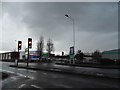
Romford Ice Rink
This is the Romford Ice Rink, as shown in John Winfield's Image, but taken head on from Rom Valley Way. Again, apologies for the darkness of the image - visibility certainly isn't at its best today! View taken looking south-southwest.
Image: © Robert Lamb
Taken: 28 Aug 2009
0.08 miles
4
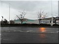
South Street, Romford
Looking south from the corner of Dymoke Road.
Image: © Trevor Harris
Taken: 22 Oct 2020
0.10 miles
5
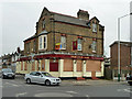
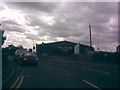
The Old Oak - another closed pub
It does not seem to be a permanent closure - yet. The "To Let" sign says it is to be let as a pub business.
Image: © Robin Webster
Taken: 2 Apr 2011
0.12 miles
6
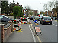
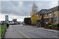
Pavement up, South Street, Romford
Something to do with gas.
Image: © Robin Webster
Taken: 2 Apr 2011
0.13 miles
7
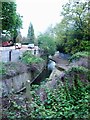
River Rom, between South St and Davidson Way, Romford
The Rom is a tributary of the Thames, and its name changes to the River Beam as it gets closer to London.
Image: © Richard Winch
Taken: 10 Apr 2017
0.13 miles
8
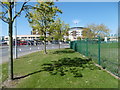
Queen's Hospital, Romford
Queen's Hospital was built on the site of the former Oldchurch Park, a short distance south of Romford town centre. Construction began in June 2003 and was completed in October 2006. Queen's is the flagship hospital of the Barking, Havering and Redbridge Hospitals NHS Trust and replaced both Harold Wood Hospital and Oldchurch Hospital when it opened in December 2006.
Oldchurch Park was the site of the original parish church of 1177. In 1410 a new church was built on the site, which itself was replaced in 1850 by the current parish church, St Edward the Confessor, located in Market Place. The remaining land eventually became gravel pits that were worked out and then used for landfill. It was purchased by the Council in 1951 and once it had settled, part of the area was made into a park in 1959. The park was mainly used for sports with pitches, tennis courts and a pavilion constructed between 1963 and 1965. Following the loss of a large part of the park to the new Queen's Hospital in 2006, the new and smaller park consists of a number of raised mounds and a wandering path; there are a few trees especially in the southern part. At the entrances are large round spaces surrounded by concrete benches. There is another concrete circle near the hospital, which is the heliport. The sports fields covered by the hospital have been replaced by equivalent facilities within the London Borough of Havering and the lost open space will be replaced in the new development on the Oldchurch Hospital site to the north of the new hospital. See also http://www.geograph.org.uk/photo/4936899
Image: © Marathon
Taken: 4 May 2016
0.15 miles
9
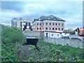
River Rom, Davidson Way, Romford
The Rom is a tributary of the Thames, and its name changes to the River Beam as it gets closer to London. A large part of it is culverted, such as can be seen here.
Image: © Richard Winch
Taken: 10 Apr 2017
0.15 miles
10
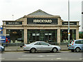
The Brickyard, South Street, Romford
This does not seem to be on the local authority's listed building register, but has somehow survived the redevelopment of this area. I am fairly sure this was originally the front for some sort of builder's yard, if not a brickyard.
Image: © Robin Webster
Taken: 2 Apr 2011
0.16 miles