IMAGES TAKEN NEAR TO
Sedgefield Crescent, ROMFORD, RM3 9RS
Introduction
This page details the photographs taken nearby to Sedgefield Crescent, RM3 9RS by members of the Geograph project.
The Geograph project started in 2005 with the aim of publishing, organising and preserving representative images for every square kilometre of Great Britain, Ireland and the Isle of Man.

There are currently over 7.5m images from over14,400 individuals and you can help contribute to the project by visiting https://www.geograph.org.uk
Image Map
Images are licensed for reuse under creativecommons.org/licenses/by-sa/2.0
Notes
- Clicking on the map will re-center to the selected point.
- The higher the marker number, the further away the image location is from the centre of the postcode.
Image Listing (8 Images Found)
Images are licensed for reuse under creativecommons.org/licenses/by-sa/2.0
Image
Details
Distance
1
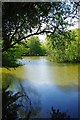
Dagnam Park Pond
This is one of several ornamental ponds in Dagnam Park. See the view in the other direction at Image
Image: © Glyn Baker
Taken: 6 May 2010
0.08 miles
2
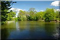
Pond in Dagnam Park
This is one of several ornamental ponds in Dagnam Park See the view in the other direction at Image
Image: © Glyn Baker
Taken: 6 May 2010
0.10 miles
3
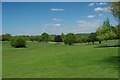
Dagnam Park View
Dagnam Park has been a public open space for around sixty years see http://www.havering.gov.uk/index.aspx?articleid=4487 and http://www.friendsofdagnampark.org.uk/ for more info.
Image: © Glyn Baker
Taken: 6 May 2010
0.16 miles
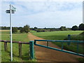
4
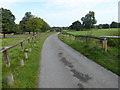
Approach to Dagnam Park
Most of the grounds of Dagnam Park were originally part of the Dagnam Estate, former home of the Wrights who lived here from 1600 to 1750, and later of the Neaves. At the northern end is the site of the original mansion, described by Samuel Pepys in 1665 as the most noble and pretty house for its size he had ever seen. An impression of its size can be seen from the fact that it had 24 hearths and was built round a courtyard with a square moat. It was demolished in the 1950s following vandalism.
Dagnam Park was bought in 1947 along with the surrounding land by the London County Council for the building of the Harold Hill Estate between 1948 and 1958.
Much fuller accounts of the history can be seen at http://www.londongardenstrust.org/features/dagnam.htm and http://www.friendsofdagnampark.org.uk/history_of_%20dagnam_park/the_history_of_dagnam_park.htm This southern part is known as The Manor Nature Reserve.
This is the approach to the park from the south leading from Settle Road.
Image: © Marathon
Taken: 6 Sep 2017
0.17 miles
5
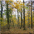
Hatter's Wood, The Manor Nature Reserve, Harold Hill
Image: © Roger Jones
Taken: 20 Nov 2016
0.21 miles
6
Entrance to Dagnam Park
Most of the grounds of Dagnam Park were originally part of the Dagnam Estate, former home of the Wrights who lived here from 1600 to 1750, and later of the Neaves. At the northern end is the site of the original mansion, described by Samuel Pepys in 1665 as the most noble and pretty house for its size he had ever seen. An impression of its size can be seen from the fact that it had 24 hearths and was built round a courtyard with a square moat. It was demolished in the 1950s following vandalism.
Dagnam Park was bought in 1947 along with the surrounding land by the London County Council for the building of the Harold Hill Estate between 1948 and 1958.
Much fuller accounts of the history can be seen at http://www.londongardenstrust.org/features/dagnam.htm and http://www.friendsofdagnampark.org.uk/history_of_%20dagnam_park/the_history_of_dagnam_park.htm This southern part is known as The Manor Nature Reserve.
Image: © Marathon
Taken: 6 Sep 2017
0.21 miles
7
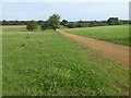
Dagnam Park
Most of the grounds of Dagnam Park were originally part of the Dagnam Estate, former home of the Wrights who lived here from 1600 to 1750, and later of the Neaves. At the northern end is the site of the original mansion, described by Samuel Pepys in 1665 as the most noble and pretty house for its size he had ever seen. An impression of its size can be seen from the fact that it had 24 hearths and was built round a courtyard with a square moat. It was demolished in the 1950s following vandalism.
Dagnam Park was bought in 1947 along with the surrounding land by the London County Council for the building of the Harold Hill Estate between 1948 and 1958.
Much fuller accounts of the history can be seen at http://www.londongardenstrust.org/features/dagnam.htm and http://www.friendsofdagnampark.org.uk/history_of_%20dagnam_park/the_history_of_dagnam_park.htm This southern part is known as The Manor Nature Reserve.
Image: © Marathon
Taken: 6 Sep 2017
0.23 miles
8
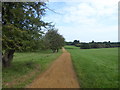
Path in Dagnam Park
Most of the grounds of Dagnam Park were originally part of the Dagnam Estate, former home of the Wrights who lived here from 1600 to 1750, and later of the Neaves. At the northern end is the site of the original mansion, described by Samuel Pepys in 1665 as the most noble and pretty house for its size he had ever seen. An impression of its size can be seen from the fact that it had 24 hearths and was built round a courtyard with a square moat. It was demolished in the 1950s following vandalism.
Dagnam Park was bought in 1947 along with the surrounding land by the London County Council for the building of the Harold Hill Estate between 1948 and 1958.
Much fuller accounts of the history can be seen at http://www.londongardenstrust.org/features/dagnam.htm and http://www.friendsofdagnampark.org.uk/history_of_%20dagnam_park/the_history_of_dagnam_park.htm This southern part is known as The Manor Nature Reserve.
Image: © Marathon
Taken: 6 Sep 2017
0.23 miles