IMAGES TAKEN NEAR TO
Paines Brook Road, ROMFORD, RM3 9JR
Introduction
This page details the photographs taken nearby to Paines Brook Road, RM3 9JR by members of the Geograph project.
The Geograph project started in 2005 with the aim of publishing, organising and preserving representative images for every square kilometre of Great Britain, Ireland and the Isle of Man.

There are currently over 7.5m images from over14,400 individuals and you can help contribute to the project by visiting https://www.geograph.org.uk
Image Map
Images are licensed for reuse under creativecommons.org/licenses/by-sa/2.0
Notes
- Clicking on the map will re-center to the selected point.
- The higher the marker number, the further away the image location is from the centre of the postcode.
Image Listing (19 Images Found)
Images are licensed for reuse under creativecommons.org/licenses/by-sa/2.0
Image
Details
Distance
1
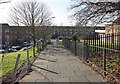
Path to St Paul's Church, Petersfield Avenue, Harold Hill, Essex
Image: © John Salmon
Taken: 21 Jan 2009
0.10 miles
3
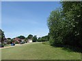
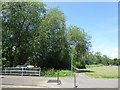
View from St Neot's Road, Harold Hill
Paine's Brook, a tributary of the Ingrebourne River, runs through the trees on the right and the London LOOP passes along the other side of the trees. Amersham Road is on the left here.
Image: © Marathon
Taken: 14 Jun 2017
0.13 miles
4
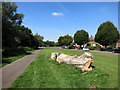
Log by the Loop
The London Loop path follows this cycleway through a strip of open space beside the diminutive Paines Brook which is in the trees on the left.
Image: © Des Blenkinsopp
Taken: 8 Sep 2014
0.13 miles
5
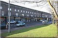
Petersfield Avenue, Harold Hill, Essex - Shops
Image: © John Salmon
Taken: 21 Jan 2009
0.14 miles
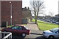
6
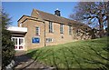
St Paul's Church, Petersfield Avenue, Harold Hill, Essex
Image: © John Salmon
Taken: 21 Jan 2009
0.14 miles
7
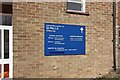
St Paul's Church, Petersfield Avenue, Harold Hill, Essex - Notice board
Image: © John Salmon
Taken: 21 Jan 2009
0.14 miles
8
The London LOOP at Harold Hill
Paine's Brook, a tributary of the Ingrebourne River, runs through the trees on the left and the London LOOP passes along the path ahead. This is looking across St Neot's Road.
Image: © Marathon
Taken: 14 Jun 2017
0.14 miles
9
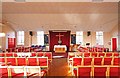
St Paul's Church, Petersfield Avenue, Harold Hill, Essex - Interior
Image: © John Salmon
Taken: 21 Jan 2009
0.15 miles
10
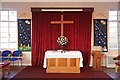
St Paul's Church, Petersfield Avenue, Harold Hill, Essex - Sanctuary
Image: © John Salmon
Taken: 21 Jan 2009
0.15 miles