IMAGES TAKEN NEAR TO
North Hill Drive, ROMFORD, RM3 9AQ
Introduction
This page details the photographs taken nearby to North Hill Drive, RM3 9AQ by members of the Geograph project.
The Geograph project started in 2005 with the aim of publishing, organising and preserving representative images for every square kilometre of Great Britain, Ireland and the Isle of Man.

There are currently over 7.5m images from over14,400 individuals and you can help contribute to the project by visiting https://www.geograph.org.uk
Image Map
Images are licensed for reuse under creativecommons.org/licenses/by-sa/2.0
Notes
- Clicking on the map will re-center to the selected point.
- The higher the marker number, the further away the image location is from the centre of the postcode.
Image Listing (14 Images Found)
Images are licensed for reuse under creativecommons.org/licenses/by-sa/2.0
Image
Details
Distance
1
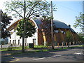
Harold Hill: My Place
Not literally my place, as this is the name of a Big Lottery funded state of the art youth centre with dance and music space, a recording studio, a bike workshop, a computer suite, a juice bar and café and a crèche. The London Borough of Havering were awarded £4,704,492 in funding to achieve the project. The photographer finds it somewhat amusing that it is such a precise figure. Woe betide the construction management team if it had cost £4,704,493. Mr Micawber would have been predicting misery...
Image: © Nigel Cox
Taken: 26 Aug 2013
0.09 miles
2

Cycleway and Loop
Sustrans cycleway No. 136 runs southwards from here down to Rainham.
Much of the way is shared with the London Loop path.
Image: © Des Blenkinsopp
Taken: 8 Sep 2014
0.14 miles
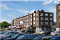
3
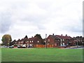
Harold Hill Estate, Romford
Harold Hill was a large 'out-County' housing estate built by the London County Council during the early 1950s on a green field site in what was then Essex. The picture shows the junction of Chudleigh Road (left) and Broseley Road (right).
Image: © David Kemp
Taken: 18 Oct 2008
0.16 miles

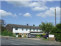
6
Two places of worship
On the right, a Kingdom Hall of Jehovah's Witnesses. On the left, an anonymous building with rather weedy surrounds. This is the Harold Hill and District Affiliated Synagogue.
Image: © Robin Webster
Taken: 30 Jun 2012
0.22 miles
7
Redevelopment hoarding, Harold Hill
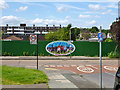
'Harold Hill Ambitions - Community Voices' is the slightly enigmatic theme of the illustration, which features mainly an elderly group bowling. This appears unrelated to the development, which replaced a comfortably spaced out residential area with small greens with higher density housing with no shared grass.
Image: © Robin Webster
Taken: 30 Jun 2012
0.22 miles
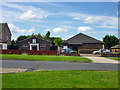
8
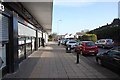
Shops on Chippenham Road, Harold Hill, Romford
Image: © John Salmon
Taken: 21 Jan 2009
0.22 miles
9
Shops, Farnham Road, Harold Hill
Including a post office.
Image: © Robin Webster
Taken: 30 Jun 2012
0.23 miles
10
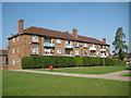
Harold Hill: Luton House, Lindfield Road
Luton House is one of nineteen similar housing blocks on the estate north of Dagnam Park Drive, all named after towns in England and Wales. The names of all 19 in alphabetical order are:-
Camelford
Epsom
Gillingham
Glossop
Halifax
Haslingden
Luton
Lynmouth
Macclesfield
Minehead
Morecambe
Nantwich
Nelson
Newmarket
Northampton
Portmadoc
Thrapston
Wilmslow
Wolverton
Quite what the connection is between these 19 is anyone's guess!
Image: © Nigel Cox
Taken: 26 Aug 2013
0.23 miles