IMAGES TAKEN NEAR TO
Earlswell Walk, ROMFORD, RM3 7GQ
Introduction
This page details the photographs taken nearby to Earlswell Walk, RM3 7GQ by members of the Geograph project.
The Geograph project started in 2005 with the aim of publishing, organising and preserving representative images for every square kilometre of Great Britain, Ireland and the Isle of Man.

There are currently over 7.5m images from over14,400 individuals and you can help contribute to the project by visiting https://www.geograph.org.uk
Image Map
Images are licensed for reuse under creativecommons.org/licenses/by-sa/2.0
Notes
- Clicking on the map will re-center to the selected point.
- The higher the marker number, the further away the image location is from the centre of the postcode.
Image Listing (27 Images Found)
Images are licensed for reuse under creativecommons.org/licenses/by-sa/2.0
Image
Details
Distance
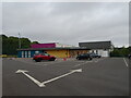
1
New Housing in Noak Hill
Looking up Le Noke Avenue.
Image: © Glyn Baker
Taken: 9 Jun 2020
0.06 miles
2
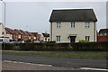
New Housing on Noak Hill Road, Harold Hill
This is a typical old Essex design of wood panelling.
Image: © David Howard
Taken: 1 Jan 2023
0.07 miles
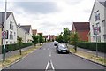
3
New housing estate in Harold Hill
This is the gradual creep into the green belt on the edge of London
Image: © David Howard
Taken: 5 Mar 2017
0.07 miles
4
Harold Hill: Site of former Noak Hill Road footbridge
This is the site of the former footbridge across Noak Hill Road, which was built in 1970 and demolished in 2013. It is planned that it will be replaced with a toucan crossing.
Image: © Nigel Cox
Taken: 26 Aug 2013
0.08 miles
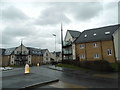
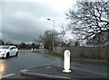
5
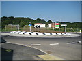
Harold Hill: New Neave Place roundabout
Persimmon Homes are developing the council's former Whitworth Centre site here. When it is complete it will have 144 new homes on it. This is the new Neave Place roundabout to the estate on Noak Hill Road.
Image: © Nigel Cox
Taken: 26 Aug 2013
0.09 miles
6
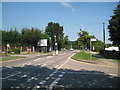
Harold Hill: Straight Road
It does exactly what it says on the tin..., running dead straight for about 1.2 miles NNW from Gallows Corner, to about where the white car is. However it was not always called Straight Road. Old Victorian large scale Ordnance Survey maps show the thoroughfare as Gallows Lane. The junction of Hailsham Road with Straight Road is in the foreground.
Image: © Nigel Cox
Taken: 26 Aug 2013
0.11 miles
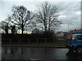
7
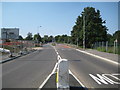
Approaching roundabout on Straight Road, Romford
Image: © JThomas
Taken: 24 Aug 2022
0.11 miles
8
Broxhill Road looking towards Noak Hill Road
Image: © David Howard
Taken: 5 Mar 2017
0.11 miles
9
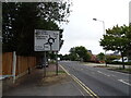
Broxhill Road at the junction of Noak Hill Road
The road has been peppered with mini roundabouts since the housing development was begun a few years ago.
Image: © David Howard
Taken: 5 Mar 2017
0.12 miles