IMAGES TAKEN NEAR TO
Shepherds Hill, ROMFORD, RM3 0NR
Introduction
This page details the photographs taken nearby to Shepherds Hill, RM3 0NR by members of the Geograph project.
The Geograph project started in 2005 with the aim of publishing, organising and preserving representative images for every square kilometre of Great Britain, Ireland and the Isle of Man.

There are currently over 7.5m images from over14,400 individuals and you can help contribute to the project by visiting https://www.geograph.org.uk
Image Map
Images are licensed for reuse under creativecommons.org/licenses/by-sa/2.0
Notes
- Clicking on the map will re-center to the selected point.
- The higher the marker number, the further away the image location is from the centre of the postcode.
Image Listing (17 Images Found)
Images are licensed for reuse under creativecommons.org/licenses/by-sa/2.0
Image
Details
Distance
2
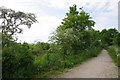
Bridleway 279
Or Cycleway 136 take your pick. Looking towards Harold Park
Image: © Glyn Baker
Taken: 15 May 2016
0.07 miles
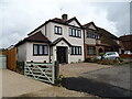
6
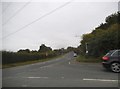
Warley Road at the junction of Hall Lane
Image: © David Howard
Taken: 3 Sep 2017
0.14 miles
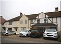
7
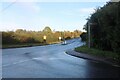
Warley Road at the junction of Hall Lane
Here is an earlier view. https://www.geograph.org.uk/photo/5525494
Image: © David Howard
Taken: 29 Oct 2023
0.16 miles
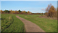
8
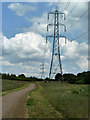
Pylons, Pages Wood
Necessarily a wide ride under the power line in the newly planted wood.
Image: © Robin Webster
Taken: 11 Jun 2011
0.17 miles
9
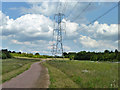
Power line across Pages Wood
The Waltham Cross to Warley route.
Image: © Robin Webster
Taken: 11 Jun 2011
0.17 miles