IMAGES TAKEN NEAR TO
Shepherds Hill, ROMFORD, RM3 0NP
Introduction
This page details the photographs taken nearby to Shepherds Hill, RM3 0NP by members of the Geograph project.
The Geograph project started in 2005 with the aim of publishing, organising and preserving representative images for every square kilometre of Great Britain, Ireland and the Isle of Man.

There are currently over 7.5m images from over14,400 individuals and you can help contribute to the project by visiting https://www.geograph.org.uk
Image Map
Images are licensed for reuse under creativecommons.org/licenses/by-sa/2.0
Notes
- Clicking on the map will re-center to the selected point.
- The higher the marker number, the further away the image location is from the centre of the postcode.
Image Listing (10 Images Found)
Images are licensed for reuse under creativecommons.org/licenses/by-sa/2.0
Image
Details
Distance
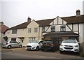
1
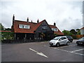
The Array Essex
On Shepherds Hill.
See Image] for sign.
Image: © JThomas
Taken: 25 Aug 2022
0.01 miles
2
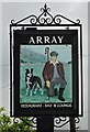
Sign for the Array Essex
See Image] for public house.
Image: © JThomas
Taken: 25 Aug 2022
0.02 miles
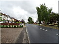
5
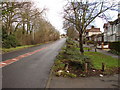
Looking up Shepherds Hill
Traffic calming measures evident on the downhill stretch.
Image: © Ian Paterson
Taken: 17 Dec 2009
0.13 miles
7
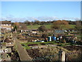
Archibald Road Allotments
View across the allotments to some nice green land beyond.
Image: © Ian Paterson
Taken: 17 Dec 2009
0.20 miles
8
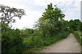
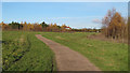
Bridleway 279
Or Cycleway 136 take your pick. Looking towards Harold Park
Image: © Glyn Baker
Taken: 15 May 2016
0.23 miles
10
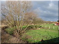
View from Cockabourne Bridge
View across the fields at the point where Shepherd's Hill meets Squirrels Heath Road. The stream is Paines Brook.
Image: © Ian Paterson
Taken: 17 Dec 2009
0.24 miles