IMAGES TAKEN NEAR TO
Brentwood Road, UPMINSTER, RM14 3TL
Introduction
This page details the photographs taken nearby to Brentwood Road, RM14 3TL by members of the Geograph project.
The Geograph project started in 2005 with the aim of publishing, organising and preserving representative images for every square kilometre of Great Britain, Ireland and the Isle of Man.

There are currently over 7.5m images from over14,400 individuals and you can help contribute to the project by visiting https://www.geograph.org.uk
Image Map
Images are licensed for reuse under creativecommons.org/licenses/by-sa/2.0
Notes
- Clicking on the map will re-center to the selected point.
- The higher the marker number, the further away the image location is from the centre of the postcode.
Image Listing (4 Images Found)
Images are licensed for reuse under creativecommons.org/licenses/by-sa/2.0
Image
Details
Distance
1
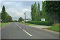
A128 past Wick Place Farm
More a place of industrial yards and units now.
Image: © Robin Webster
Taken: 18 Sep 2011
0.06 miles
2
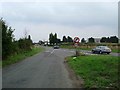
Wick Place and the A128
This is the Junction of Wick Place and the A128. This is a notorious accident black-spot the 50mph limit and no right-turn are recent introductions
Image: © Glyn Baker
Taken: 10 Sep 2005
0.15 miles
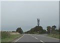
4
Wick Place Telecom's Tower
This telecom’s tower is located on the junction of the A128 and Wick Place.
Image: © Glyn Baker
Taken: 10 Sep 2005
0.21 miles